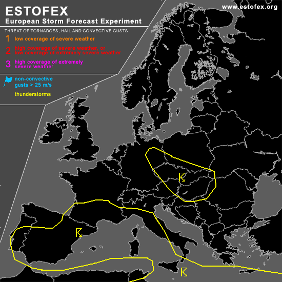

STORM FORECAST
VALID Thu 27 Apr 06:00 - Fri 28 Apr 06:00 2006 (UTC)
ISSUED: 26 Apr 21:47 (UTC)
FORECASTER: DAHL
SYNOPSIS
Intense vort max ejecting from NRN-stream upper trough covering the Norwegian Sea is expected to reach the North Sea/Denmark late in the period ... where it is progged to evolve into an upper cut-off low. Upper frontal zone over the Mediterranean is expected to undergo some strengthening as extensive upper low over the central Mediterranean deepens somewhat. Several vort maxima will be present at its southern periphery.
DISCUSSION
...southeast-central Europe...
Scattered TSTMS should develop in weakly unstable/weakly capped air mass with daytime heating ... large-scale kinematic support will also be minimal ... and organized severe
threat should be accordingly low. However ... the strongest cells may briefly produce marginally severe weather if cells favorably interact with the local orography or outflow-boundaries. Threat should be too low for a categorical risk.
...Spain...
Scattered TSTMS should also develop over Spain ahead of weak vort max in the evening hours. CAPE should be rather weak ... but CBLs are becoming increasingly deep and supportive of strong downdrafts. Deep shear should also increase in the early evening hours so that an isolated/brief severe wind event cannot be discounted. However ... storms should be rather isolated and a categorical risk does not seem to be necessary ATTM.
...south Ionian Sea...
Though it does not seem that rich boundary layer moisture will be in place as dry air from the S Balkans is advected westward N of the SFC low grazing the S Ionian Sea on Thursday ... at least elevated convection should persist ahead of rather strong DCVA-forced ascent. Shear in the cloud-bearing layer will likely be reduced compared to 0-6 km bulk shear magnitudes ... and severe threat should be limited. However ... dry environment should promote strong downdrafts ... also ... if storms manage to tap
boundary-layer air their severe potential should increase. Indications are that bulk of activity will occur over the water ... and S of the forecast area. GFS does not advertise any CAPE over the Ionian Sea and confidence in SFC-based evolution is thus limited. Latest lightning data however reveal the presence of CAPE where GFS simulated none ... which seems to justify introduction of TSTM area over the S Ionian.
#