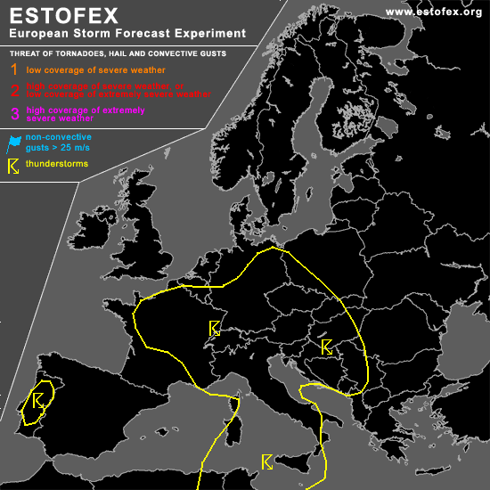
STORM FORECAST
VALID Wed 26 Apr 06:00 - Thu 27 Apr 06:00 2006 (UTC)
ISSUED: 25 Apr 19:05 (UTC)
FORECASTER: TUSCHY
SYNOPSIS
Weak pressure spread present over most parts of Europe... A warm and humid airmass should yield the possibility for widespread TSTM development over most parts of CNTRL Europe ( mainly topographical forced )...Strongest instability is forecast to develop north of Austria and the Czech Republic, but weak wind shear will preclude any organized TSTM development in this area ( like the rest of CNTRL Europe).... Maturing storms could locally pose a marginal hail and sub-severe wind gust risk.
Eastern Europe will see cool and stable conditions.
Broad sector with cold mid-/upper level airmass will cross the region of the Faroe Islands...Isolated storms can't be ruled out, but coverage is expected to be too low for highlighting an area.
DISCUSSION
...France and most parts of Germany...
Main focus for TSTM initiation will be a slowly S/SE-ward moving cold front... Instability not impressive over most parts of France and in conjunction with a very weak wind field, no severe weather threat is anticipated.
Further towards the east, airmass is forecast to be more humid and up to 300 J/kg (locally more) SBCAPE can be expected over southern and eastern Europe... Slowly SE-ward shifting front should give enough forcing for scattered TSTM development...Moderately steep lapse rates and moderate instability values should be enough for isolated stronger pulsating storms with an attendant marginal hail risk, but wind shear too weak for an organized TSTM threat.
...N-Tunisia and Sicilia...
Broad trough will slowly shift towards the east and attendant cool-mid-level airmass will help for moderate instability release over the area of interest...Models like GFS and NMM show the bulk of the convective precipitation to develop under the core of this trough, where shear parameters would be too weak for severe TSTMs...Main threat for N-Tunisia looks like to be a flash flood threat with the stronger storms (PW values up to 30mm ).
Low-end instability also forecast to develop over Sicilia where wind shear will be slightly enhanced... Current thinking is that environment will be too hostile for significant TSTM development / coverage and will hence stay with a TSTM line ATM.
#