STORM FORECAST
VALID Tue 25 Apr 06:00 - Wed 26 Apr 06:00 2006 (UTC)
ISSUED: 25 Apr 09:17 (UTC)
FORECASTER: VAN DER VELDE
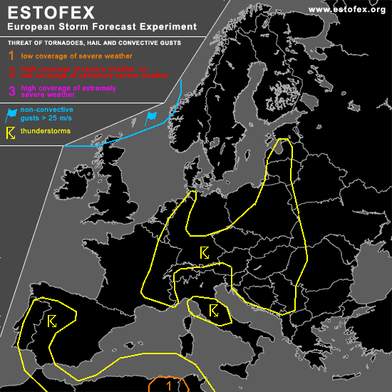
A threat level 1 is forecast across northeastern Algeria and western Tunesia
SYNOPSIS
Large scale saddle area over Europe, with depressions affecting Scotland (cold front into UK) and western Norway, as well as North Africa with a side lobe to Spain. Dry air from Russia bounds the convective airmass at the east side. A small upper cold pool still affects the region of northeastern Poland and the Baltic states. Over most of convective Europe there is no deep layer shear and trigger of significance to keep storms going - storms will occur mainly near orographic features.
DISCUSSION
...northeastern Algeria and western Tunesia...
Instability combined with >250 m2/s2 storm-relative helicity and moderate deep layer shear (15-20 m/s 0-6 km) will continue to produce long-lived storms with a chance of large hail and severe gusts, and tornadoes may also be possible given enhanced 0-1 km shear (>10 m/s).
...Northeastern Poland, Baltic States...
GFS model indicates small >25 m/s deep layer shear streak, which may yield a well-organised storm producing some marginally large hail, but overal coverage doesn't seem to be high. 0-1 km shear will not be much special. Convergence along a fairly stationary linear zone is present in GFS/NMM, which will be the focus for convection, but instability is marginal.
...western Germany into Denmark...
A convergence zone and advection of low-level moisture northward ahead of a frontal zone leads to some very marginal instability in NMM and GFS models, but it seems the depth of convection is limited (forecast EL around -10C level). Thunder, if any, will be modest.
#