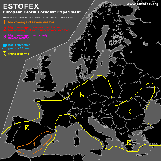

STORM FORECAST
VALID Sat 22 Apr 06:00 - Sun 23 Apr 06:00 2006 (UTC)
ISSUED: 21 Apr 23:17 (UTC)
FORECASTER: DAHL
A threat level 1 is forecast across eastern Spain.
SYNOPSIS
Short-wave trough over the North Sea late Friday evening ... will close off into a small upper cut-off low and stall over NRN Germany on Saturday. Comparatively large upper low over the western portions of the Iberian Peninsula is progged to drop slowly southwards ... thereby enhancing mid/upper ridging over the W Mediterranean. Weak vort maxima will affect the central Mediterranean as well as the S Balkans and Turkey during the period. At the SFC ... quiescent conditions are expected to persist across the central and SRN portions of Europe ... though rather extensive SFC low over the N Maghreb States should strengthen somewhat in response to approaching Iberian upper low ... promoting increasing E/SELY flow over the W Mediterranean and Spain towards the end of the forecast period.
DISCUSSION
...eastern Spain...
TSTMS should re-develop over Spain in weakly unstable/neutral air mass during the early afternoon hours. Though large-scale upward forcing should be limited ... minimal capping should support rather widespread convective development. Deep shear in excess of 30 m/s is expected to exist over eastern Spain ... with increasing low-level shear in the evening and night hours. Also ... it seems that a N Saharan EML will overspread the SW Mediterranean and E Spain in the evening/night hours ... at the nose of which /possibly elevated/ convection should form. Shear profiles should support multicellular storms ... capable of producing marginally severe wind/hail. Late in the period ... increasing LL shear may enhance supercell/tornado threat over E Spain if SFC-based evolution is realized.
...Germany ... W Poland ... Chech Republic...
Scattered TSTMS should persist/re-develop in weakly unstable air mass during midday ahead of small cut-off low along associated weak low-level cold-frontal boundary ... and in weak WAA regime ahead of the front. Mesoscale band of about 15 m/s mid-level winds is expected to exist along the periphery of the upper low ... providing marginal deep shear for organized convection. LL shear is somewhat uncertain as some model-to-model variance exists on the strength of developing SFC low ahead of the upper feature over Germany.
Expect majority of the TSTMS to be non-severe given minimal CAPE and mesoscale nature of marginally favorable deep shear profiles. An isolated marginally severe wind/hail event could occur though ... but coverage is currently anticipated to be too low for a categorical risk. An upgrade may be required if especially the low-level shear turns out to be more ample than currently anticipated so that the threat of mesocyclones increases.
...SE Europe...
Scattered TSTMS should form across portions of SE Europe with diurnal heating ... augmented by weak DCVA-related ascent which should affect primarily Greece and Turkey. Thermodynamic profiles should be quite weak ... but marginal deep shear of about 20 m/s should be present over southern Greece and southern Turkey. Expect an isolated marginally severe hail/wind event ... but coverage should be below level-one thresholds.
#