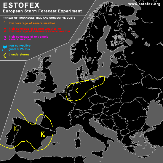
STORM FORECAST - UPDATE
VALID Fri 21 Apr 19:00 - Sat 22 Apr 06:00 2006 (UTC)
ISSUED: 21 Apr 18:50 (UTC)
FORECASTER: TUSCHY
SYNOPSIS
Please refer to the oulook, released at 20 Apr 21:21 (UTC)!
Did not highlight the broad TSTM area over central Europe again, because of starting rapid decrease in TSTM activity.... Don't want to exclude that some TSTMs could still develop, but no severe weather criteria will be fulfilled.
DISCUSSION
...parts of Belgium, the Netherlands,N-Germany...
Confidence in TSTM development mainly over NW/CNTRL Germany increased during the past few hours, so an update for those areas has become necessary!
At least 3 weather systems will play a role in tonight's possible TSTM development.... First one is an upper-level cold pool, placed over the extreme SE North Sea...Current satellite presentation is not very impressive ( only a few and pretty warm convective tops ), but ΔT will increase, when cold mid-level temperatures will come onshore ( during the midnight hours).
Second system will be a confluence zone/weak cold front, which is forecast to slowly shift towards the SE, reaching central Germany during the latter part of the forecast period.
Finally, broad area of marginal pressure fall over E/NE Germany occured during the past few hours and a weak low pressure area(~1014hPa) developed.
Current thinking is that isolated to scattered storms will develop along the front and under the base of the mid-level cold core system in a weakly capped environment with steepening mid-level lapse rates...Models indicate instability values near zero, but modified soundings from this area would favor at least 50-100 J/kg and this should be enough for TSTM development( although this should finally constrict tonight's storm development )...
DLS will increase to 20-25m/s, when mid-/upper-level wind field continues to strengthen and there will be a marginal hail threat with the stronger storms.
Isolated storms could also develop over E-Germany under the broad low pressure area in an environment with low-end instability and weak wind shear, so don't expect any storm organisation.
Models also indicate convective precipitation development over NW Poland,as a result of a rapidly SE-ward moving vort max...Because of very marginal instability release, only a few storms should develop....environmental LL shear is enhanced and there could be an isolated severe TSTM event, but coverage will be too low for issuing higher probabilities.
#