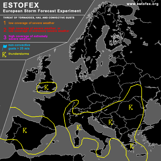
STORM FORECAST
VALID Fri 21 Apr 06:00 - Sat 22 Apr 06:00 2006 (UTC)
ISSUED: 20 Apr 21:21 (UTC)
FORECASTER: TUSCHY
SYNOPSIS
Early spring-like weather pattern will continue for most parts of central and eastern Europe... Pool of cool mid-level airmass, running from the central Mediterranean to the Black Sea, and accompanying steeper lapse rates will be enough for widespread low-end to moderate instability release... Most concentrated TSTM development is expected to evolve over Italy and SE Europe...again...weak wind shear will preclude any organized TSTM development and main risk looks like to be a marginal hail and mostly sub-severe wind gust threat.
Weak pressure contrast will be also present outside of the highlighted TSTM area ( e.g. Germany, mountainous areas of the Alpes ), but coverage is expected to be too isolated for including those areas.
Upper-level trough, placed over the western part of the Bay of Biscay, driped off during the past few hours and should slowly drift towards the south...Once again, this system will be the focus for at least isolated severe TSTM development.
DISCUSSION
...Portugal and Spain...
First area for TSTM development will be a slowly southeastward moving cold front ( crossing CNRTL Spain during the noon hours)... Current thinking is that cold front will slow down significantly due to near parallel alignment to the back-ground flow...Bad timing ( during the morning/early noon hours )will confine TSTM development and coverage should be marginal over CNTRL Spain...Separation of jet energy and best thermodynamic environment should also limit the possibility for organized TSTMs....Storms should increase over the eastern part of Spain later on, when front will reach a more humid airmass and day-time heating will re-activate the cold front...Increase in DLS ( up to 20m/s ) would favor mainly a large hail risk with each TSTM.
Next round of convection will develop during the late noon/afternoon hours over NW Spain/Portugal, when pool of cold mid-level airmass will come onshore...GFS and NMM also show the arrival of some wrap-around moisture during the early evening hours over western Portugal...DLS up to 20m/s will be enough for a severe wind gust threat with strongest storms....but don't expect widespread TSTM initiation ATM and will therefore stay with a general TSTM are....Storms are forecast to develop towards the south during the night hours, mainly along the coastal areas, where highst pockets of instability can be found.
#