STORM FORECAST
VALID Wed 19 Apr 06:00 - Thu 20 Apr 06:00 2006 (UTC)
ISSUED: 18 Apr 23:43 (UTC)
FORECASTER: GROENEMEIJER
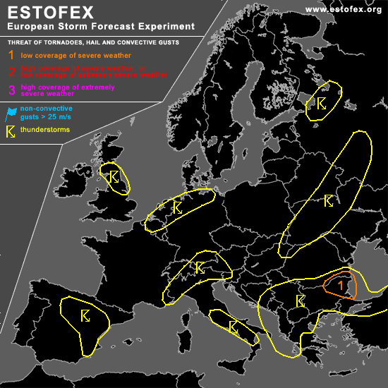
A threat level 1 is forecast across eastern Bulgaria and extreme southeastern Romania
SYNOPSIS
Wednesday at 06:00 UTC... a polar jet stream is present around 55 N stretching from the Atlantic to northwestern Russia. A shortwave trough over the eastern Atlantic is expected to cross Great Britain during the afternoon hours. Strong zonal flow is present across the Mediterranean Sea as well. A shortwave trough initally over the Adriatic is expected to cross the Balkans during the day.
DISCUSSION
...eastern Balkans, Bulgaria...
An elevated mixed layer is advected northward over the Aegean Sea. Elevated convection is expected to be ongoing at the beginning of the forecast period across Croatia, Albania, Serbia and the F.Y.R. of Macedonia at the beginning of the period. The convection shifts eastward in concert with the upper system and a surface low initially located over the Adriatic shifts eastward to reach central Bulgaria around 21Z. Insolation will likely play an important role as a dry upper-level air is advected into eastern Bulgaria during the late morning or early afternoon. This may destabilize the boundary layer sufficiently to allow for surface-based convection. About 20 m/s deep-layer shear and strong veering of the low level wind should be present in eastern Bulgaria and perhaps extreme southeastern Romania in the vicinity of a low-level warm front. Therefore, the storms could turn into right-moving supercells with some risk of one or two tornadoes forming in addition to some large hail. Shear and instability are expected to decrease during the evening hours, so that the severe threat should quickly diminish.
...northern England, southern Scotland...
Strong insolation is expected to lead to destabilisation during the afternoon hours across the area. As deep-layer shear should be strong with aroudn 30 m/s of 0-6 km bulk shear, the storms may become organized into one or two small bows capable of producing gusty winds and some hail. The formation of a rotating updraft with a small possibility of a brief tornado can not be discounted, but the overall threat of severe weather is too low for a level 1.
#