STORM FORECAST
VALID Tue 18 Apr 06:00 - Wed 19 Apr 06:00 2006 (UTC)
ISSUED: 18 Apr 01:21 (UTC)
FORECASTER: VAN DER VELDE
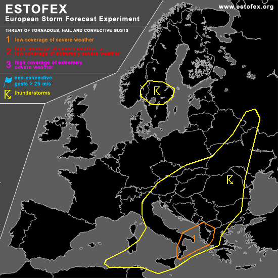
A threat level 1 is forecast across southern Italy, Albania, and western Greece
SYNOPSIS
Convective activity can mostly be found in the southeastern half of Europe today, associated with a very baroclinic surface depression with its core near Sicily, moving towards the southern Adriatic Sea. Over the southern Mediterranean models forecast an upper trough initially with a positive tilt progressing into a vigorous negatively tilted trough affecting SErn-most Italy and the southern Balkan. Over the northern Balkan towards central Europe a marginally deeply unstable airmass resides in a saddle area, which is most likely to yield isolated thunderstorms over elevated and dry grounds.
An old depression with upper cold air overhead will initiate fairly harmless thunderstorms mainly over central Sweden.
DISCUSSION
...southern Italy, southwestern Balkan...
GFS and NMM models forecast CAPE over southeastern Italy and Albania in the afternoon. This seems a somewhat tricky setup, because drier air off Africa is being advected towards this region, with the higher mixing ratio airmass turning around the west side of the low. A 2-4 km lapse rate maximum (near dry adiabatic) shows up in GFS over the same region indicating an elevated mixed layer. Concern is that this may indicate a too dry or capped steep lapse rate lower troposphere inhibiting convection, even with the strong lift associated with the PVA of the upper trough - and storms may form more NW-ward instead, where more boundary layer moisture is present.
Despite the question of instability, the overall setup does seem to hold potential - deep layer shear vectors over 20-25 m/s and storm-relative helicity values over 200 m2/s2 caused by strong directional veering overlap partially the region with forecast instability. This implies storms can be maintained for a long time and organised due to the PVA lift. Some may develop rotating updrafts with a chance of producing large hail and/or a tornado, on an isolated scale.
More to the west over central Italy and western Balkan, conditions for thunderstorms seem more secure, but due to weaker upper winds shear parameters are not as favourable for severe storms. They may bring mostly non-severe hail.
#