
STORM FORECAST
VALID Sat 15 Apr 06:00 - Sun 16 Apr 06:00 2006 (UTC)
ISSUED: 14 Apr 19:34 (UTC)
FORECASTER: DAHL
SYNOPSIS
Dominant feature this period will be W European upper trough ... whose peripheral vort maxima will cross the Iberian Peninsula ... France ... and the W Mediterranean on Saturday. Upper trough imbedded in a NRN frontal zone will dig into the Ukraine until late Saturday evening ... thereby phasing with upper cut-off low over the Aegean ... which will continue its eastward motion as a result. At low levels ... only noteworthy feature seems to be a plume of warm mid-level temperatures ... possibly associated with a weak EML ... that will spread across E Spain ... parts of France and the W Mediterranean.
DISCUSSION
...Iberian Peninsula and France...
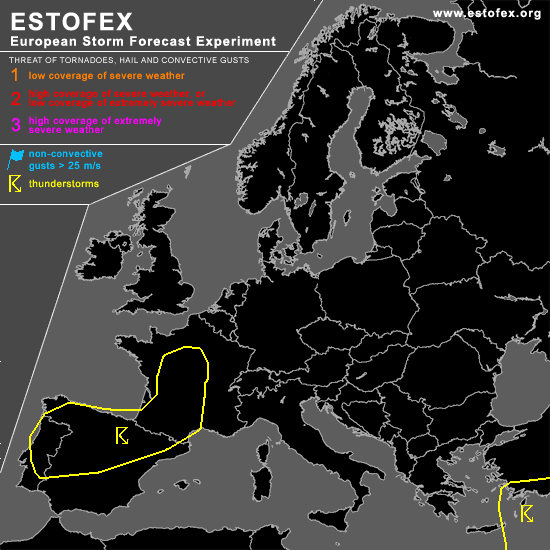
Latest GFS runs suggest that weak instability will develop in relatively warm air over Spain and France ahead of rather vigorous vort maxima. First DCVA-related UVV regime should overspread France in the early afternoon hours ... and a second one should cross Spain in the late afternoon and evening hours. Development of instability is not really supported by Friday's 12Z launches from Spain/Portugal ... but given spatial scarcity of radiosonde observations ... this does not preclude presence of at least nearly unstable profiles across the country. However ... confidence in development of positive CAPE is solely based on the GFS ATTM. Also ... current lightning activity seems to be less than what would be expected from GFS fields. Hence ... some uncertainty exists on evolution of positive CAPE on Saturday.
Shear should be just adequate for severe evolution with ample mid/upper-level flow expected ... but confidence in widespread convective development is quite limited ... and will thus not introduce a categorical risk. An update may be required if coverage of TSTMS turns out to be larger than currently anticipated.
...central Ukraine...
Shallow convection should spread across the central Ukraine in the afternoon hours. Low EL's should preclude widespread lightning ... though sporadic TSTMS could occur. Coverage is expected to be too low for a TSTM area.
...E Mediterranean...
TSTMS should continue in nearly neutral thermodynamic environment beneath Aegean cut-off low ... which will travel eastward on Saturday. Bulk of activity in the forecast area associated with this feature should form in relatively barotropic environment with accordinly little shear. However ... a waterspout or two seems to be possible.
#