STORM FORECAST
VALID Fri 14 Apr 06:00 - Sat 15 Apr 06:00 2006 (UTC)
ISSUED: 13 Apr 20:04 (UTC)
FORECASTER: TUSCHY
SYNOPSIS
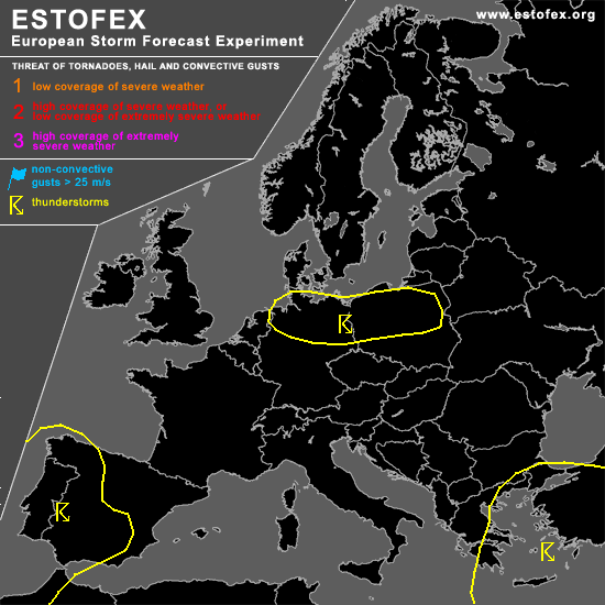
Most parts of northern-eastern Europe will be covered by a slowly eastward propagating upper-level trough... Cool and stable conditions will limit TSTM development to the highlighted areas....Significant warm-up will occur over most parts of the central and western Mediterranean as a result of a developing depression WNW of Spain.
DISCUSSION
...N-Germany and most parts of Poland...
Cooling of mid-/upper levels will induce steeper lapse rates and the chance for low-end instability release over a broad area... Timing looks favorable for N-Germany ( left exit region of 45m/s streak at 500hPa, passing pool of cold mid-level airmass <-30°C at 500hPa )and expect scattered showers and TSTMs to develop during the later noon/afternoon hours... Main threat will be a marginal hail/ strong wind gust risk.
Same conditions further towards the east... Expect scattered TSTMs to develop over a broad area in an environment with bad kinematic parameters and therefore no organized TSTM threat.
...Aegean Sea...
Scattered TSTMs expected to develop under the base of a weakening upper-level trough... Weak wind shear will preclude any organized severe TSTM risk.
...Portugal and parts of Spain...
Cold front, moving onshore along the western coast areas of Portugal during the later afternoon hours, will shift towards the east.....Despite the fact that models indicate no instability signals, there are quite a few facts, which point towards the possibility for TSTMs to develop.... Model pool agrees in the development of intense convective precipitaion over parts of N Portugal... Strong jet streak will induce strengthening upper-level divergence over the region, combined with forcing of eastward advancing cold front... Interesting to note, that quite a few models indicate the arrival of a well developed dry slot during the evening hours, crossing the front from the SW... Too many uncertainness ATM, but area has to be monitored for any storms to develop.... Shear would be more than adequate for organized TSTMs!
Although forecast soundings from S/SE Spain are well capped due to ongoing WAA, models like GFS and NMM indicate the development of TSTMs... Don't expect more than an isolated storm to develop and higher probabilities are not anticipated ATM.
#