
STORM FORECAST
VALID Wed 12 Apr 07:00 - Thu 13 Apr 06:00 2006 (UTC)
ISSUED: 12 Apr 06:52 (UTC)
FORECASTER: GATZEN
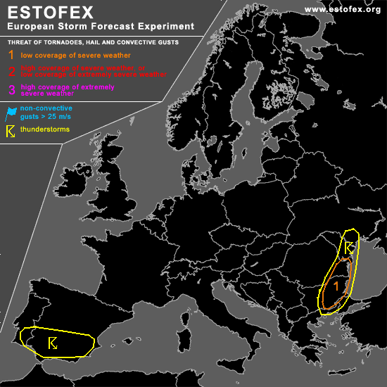
A threat level 1 is forecast across eastern Bulgaria, eastern Romania
SYNOPSIS
Long-wave trough centered over Europe ... with an axis from North Sea to Adriatic. At the southern periphery ... intense short-wave troughs /vort-maxima rotate around the trough's base ... affecting western central Europe/Alpine region/Adriatic, and southern/eastern Balkans today. Especially over the Balkans ... strong QG forcing is expected ... and surface low-pressure system now over western Bulgaria should intensify during the day as it moves into southwestern Ukraine. To the west ... Atlantic ridge spreads eastward ... affecting most of western Europe. Weak upper trough will remain at the southern flank of this ridge from central Atlantic to southern Iberian Peninsula ... providing a strong subtropical jet over the northern border of Africa. At lower levels ... northerly surface winds east of western European high-pressure system advect cool/dry airmass into Mediterranean, while quite warm airmass should be present over southern Iberian Peninsula. Over eastern Balkans/Black Sea region ... WAA is expected ahead of the short-wave trough.
DISCUSSION
...Eastern Balkans, Black Sea region...
Surface low is now centered over northwestern Bulgaria and is expected to move to northeastern Romania during the day. At its eastern/northern flank ... warm airmass should affect eastern Bulgaria, eastern/central Romania, and southern Ukraine during the period. Latest LRBS Bucuresti sounding indicates steep lapse rates from 900 to 800 hPa ... that should likely be present over the area of interest today. Boundary layer moisture should increase below a low-level inversion ... and GFS indicates low-level mixing ratio of about 8g/kg during the day. However ... latest satellite image indicates a broad cloud shield north of the surface low ... while low-level clouds cover most of the region south of this cloud shield. As a consequence ... diurnal heating should be quite weak today. Expect that some heating takes place in the warm sector airmass ... surface temperatures may rise as high as 17/18°C ... while low-level moisture should increase. Given strong QG forcing as the upper vort-max approaches ... mid-levels may cool ... and weak CAPE may materialize. Some showers and thunderstorms may develop along and ahead of the cold front today. Given moist low-level airmass and rather low LCL heights ... as well as low-level easterly winds and enhanced low-level helicity around 100 J/kg ... chance for mesocyclones should be enhanced as well an the chance for tornadoes. Given weak diurnal heating
convection should weaken during the afternoon/evening.
...Southern Iberian Peninsula...
With easterly low-level winds ... moist boundary-layer airmass has been advected into southern Iberian Peninsula. Aloft ... moderate to strong westerly jet affects the region ... and moderate to strong DLS is forecast. Given diabatic heating during the day ... thunderstorms are expected to form over the mountains of southern Iberian Peninsula ... that should organize into multicells capable of producing intense precip and severe wind gusts. Although QG forcing is forecast to be weak ... local flash flooding is not ruled out with the stronger storms. Isolated supercells may also evolve ... with large hail/intense rain the most significant threat. Convective activity is forecast to weaken in the evening hours. Allover threat should be low, though.
#