STORM FORECAST
VALID Tue 11 Apr 06:00 - Wed 12 Apr 06:00 2006 (UTC)
ISSUED: 10 Apr 19:59 (UTC)
FORECASTER: TUSCHY
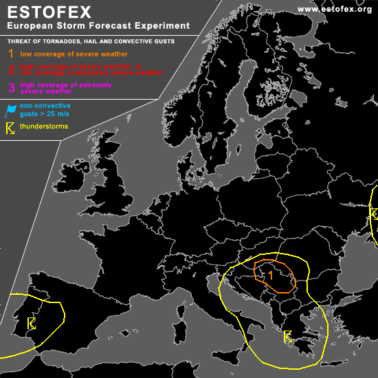
A threat level 1 is forecast across southern Hungary,eastern Croatia,most parts of Serbia and Montenegro and extreme northern part of Bosnia and Herzegovina
SYNOPSIS
An intense subtropical jet has established over most parts of southern Europe... Intense upper-level trough, placed over central Europe, causes a strengthening baroclinic zone and hence an intensifying jet streak over the central Mediterranean ... This impulse will help to shift the upper-level trough slowly further towards the east,taking in a negative tilt during the next 24 hours.
This activity will be accompanied by a broad area of low pressure east of Italy and a well developed depression is forecast to shift slowly towards the east, starting to intensify during the latter part of the period over the highlighted area.
DISCUSSION
...southern Hungary,eastern Croatia,most parts of Serbia and Montenegro and extreme northern part of Bosnia and Herzegovina...
Strongly sloped system currently evolves over northern Italy and will move towards the east during the forecast period.... Main focus for convective development will be the low-level depression over Croatia/Bosnia and Herzegovina/Serbia and Montenegro/ Hungary....Models like GFS indicate no significant change in the temperature profile in the mid/ upper airmass till the early morning and noon hours... A slight cool down and a substantial increase in low-level moisture should yield moderate instability values ( modified sounding of Beograd).... Areas of up to 400 J/kg look reasonable ATM and scattered TSTM development can be expected over the level 1/sourrounding area(s).... Main uncertainty will be the timing of intensification of the low-level depression.... Impressive upper-level divergence and approaching trough should offer a favorable environment for an intensifying depression and hence a strengthening wind field.... GFS indicates an increase during the afternoon hours ( low-level shear up to 12m/s and DLS 15-20m/s )and this should be enough for a few organized storms to form with an attendant hail/severe wind gust risk...also don't want to rule out one or two tornadoes due to low LCLs and moderately enhanced 0-1km helical flow....Storm coverage should decrease during the night hours due to easing instability.
Eastward shifting upper-level trough should produce widespread low-end instability development over most parts of the Adriatic Sea...Weak wind field won't be favorable for an organized TSTM threat.
Broad area ( S-Adriatic Sea towards Greece ) will also be monitored for TSTM development.... Despite only weak instability signals, GFS/NMM indicate broad area of convective precipitation during the afernoon/night hours....On the one hand, EML is not that impressive and strong lift is forecast to cross those regions but then also don't see that much insolation for those areas... Will therefore stick to a TSTM line for the moment.... Expect isolated storms to develop in a violent environment(up to 35m/s DLS) with an attendant risk for severe-damaging wind gusts.
...most parts of Portugal and SW/W-CNTRL Spain...
Broad area of cool mid-level airmass runs from Portugal to the Azores and further towards the west.... As a result, impressive subtropical jet core has been established during the past 24 hours ( peaking with up to 160kt somehwere over the Canaries)... This streak should slowly shift towards the NE, approaching the regions of SW Spain and Portugal during the next 24 hours....As a result, models indicate increasing upper-level divergence in the left exit region over a pretty broad area.... Superposing cool mid-level airmass and divergence should be the focus for an area of enhanced TSTM development....Despite ~ 500 J/kg SBCAPE, wind field will be too weak/ displaced to the south and don't expect an organized severe TSTM threat....Steepening mid-level lapse rates would yield a marginal hail risk and mainly sub-severe wind gusts.
#