STORM FORECAST
VALID Mon 10 Apr 06:00 - Tue 11 Apr 06:00 2006 (UTC)
ISSUED: 09 Apr 22:31 (UTC)
FORECASTER: GROENEMEIJER
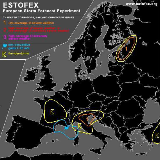
A threat level 1 is forecast across northern and central Italy, western Slovenia
A threat level 1 is forecast across eastern Estonia and Novgorodskaya, Pskovskaya and Leningradskaya Oblast's
SYNOPSIS
Monday at 06:00 UTC... an elongated trough stretching from southern Norway to western France is expected to have evolved into a closed low over northwestern Italy on Tuesday morning. Moderately steep mid-level lapse rates of around 7 C/km are advected northward ahead of a front that moves southward over southern France ahead the trough. In combination with 8 g/kg low-level moisture... this should allow for the formation of some CAPE in a couple of places. In the wake of the front, a polar air-mass, although relatively dry, should be able to destabilize sufficiently to allow for some thundery showers.
DISCUSSION
...northern and central Italy, western Slovenia...
A couple of convective storms will probably form across the southern Po-Valley and possibly a few 100s of kms further southward during the afternoon despite the rather weak instability values expected.
As 0-6 km bulk shear is expected to be locally in excess of 30 m/s atop veering low-level winds, storms should rather easily become supercells with some threat of large hail. If the convection becomes surface-based... which is not clear at the moment... a threat of tornadoes will be present as well. The chance of this to happen is the largest east of the Apennines and across the southern Po Valley.
During the late evenin, clustered convective storms will likely cluster and move eastward into Slovenia where the severe threat should subside.
...eastern Estonia and Novgorodskaya, Pskovskaya and Leningradskaya Oblast's...
Within a polar air-mass, convective storms are expected to form ahead of a vorticity maximum that crosses the area during the afternoon. Given strong 0-6 km bulk shear of around 30 m/s under a strong westsouthwesterly jet, storms should rapidly organize into small bows. These may bring strong to marginally severe gusts. Locally, rotating updrafts may form that bring an attendant threat of large hail and possibly a short-lived tornado.
#