
STORM FORECAST
VALID Wed 05 Apr 06:00 - Thu 06 Apr 06:00 2006 (UTC)
ISSUED: 04 Apr 20:37 (UTC)
FORECASTER: GATZEN
SYNOPSIS
To the east of high geopotential over northern Atlantic ... complex system of short-wave troughs is present over Europe. While polar troughs are present W of Iberian Peninsula ... over France ... and over Black Sea region ... an arctic trough has moved into southern Scandinavia. At lower levels ... cold maritime airmass has spread into Europe north of a line from central France to southern Germany and further to eastern Poland/ Baltic states. South of this line ... temperate airmass is present over western Mediterranean region .... while rather cool airmass has spread into eastern Mediterranean /southeastern Europe in the wake of a long-wave trough over central/eastern Turkey. During the period ... Iberian short-wave trough moves NE-ward into Alpine region ... leaving a short-wave trough W of Iberian Peninsula and yielding WAA over northern Mediterranean ... and Balkans. To the NE ... another short-wave trough travels NE-ward over Black Sea region. Over Baltic Sea region ... arctic trough propagates NE-ward.
DISCUSSION
...Western Iberian Peninsula
...
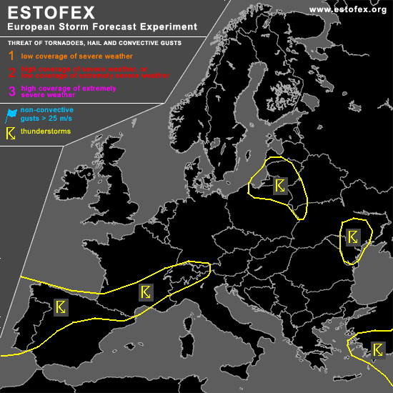
One focus of possible severe convection will be the western part of Iberian Peninsula. Convectively mixed maritime airmass is expected to spread into this region and should lead to showers and thunderstorms given weak CIN and rather rich low-level moisture. At the eastern flank of developing cut-off low ... strong SW-erly flow is expected to affect western Iberian Peninsula ... yielding strong DLS. Showers and thunderstorms that form will probably organize into multicells or supercells given enhanced SRH values. However ... mode of convection is not clear ATTM ... given an occlusion moving into the region that may provide mid-level clouds and stratiform rain. Current thinking is that thunderstorms will be embedded within this front ... and chance for well-organized thunderstorms seems to be limited.
...Southern France/western Alps
...
Potential for a few thunderstorms is expected along the frontal boundary over France and western Alps. Warm airmass south of the front is rather dry ... but latest model output suggests that weak instability will possibly form near the frontal boundary. Although later observations have to confirm this forecast ... current thinking is that weak instability should likely develop ... as mid-level lapse rates are quite steep and low-level moisture may recover near the front. Given weak short-wave trough traveling eastward over France/Alpine region ... as well as low-level forcing in the range the front and steep orography ... a few thunderstorms are forecast to form. Underneath the strong jet ... moderate vertical wind shear should be present ... and thunderstorms may organize. Supercells are not ruled out capable of producing large hail and severe wind gusts. Due to weak low-level moisture ... chance for tornadoes seems to be relatively low. Allover threat seems to be marginal.
...Baltic states
...
In the range of propagating arctic trough axis ... cold maritime characerized by neutral lapse rates and weak CIN shoud destabilize in response of diurnal heating ... and showers/tstms are expected. Given strong vertical wind shear ... some showers may be intense and capable of producing soft hail and strong gusts. A tornado is not ruled out ... but overall threat should be marginal.
#