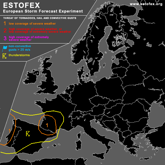
STORM FORECAST - UPDATE
VALID Tue 04 Apr 18:00 - Wed 05 Apr 06:00 2006 (UTC)
ISSUED: 04 Apr 18:13 (UTC)
FORECASTER: TUSCHY
A threat level 1 is forecast across NE Spain and SW France
A threat level 1 is forecast across coastal areas of western Portugal and Spain
SYNOPSIS
Please refer to the synoptic discussion issued at 03 Apr 22:34 (UTC)!
DISCUSSION
...NE Spain and SW France...
Stout cap lived up its promise, holding off TSTM development till the early evening hours.... However, ridge axis already left the area of interest and cooling trend of the mid-levels should be already underway... 1000hPa low level depression , positioned in the extreme SE part of the Bay of Biscay, is ready to move onshore along the SW coast of France... A more humid airmass will accompany this depression, so conditions should become favorable for marginal instability release...Despite this limiting factor, still expect scattered TSTMs to develop/go on in the level 1 area... TSTMs over NE Spain and south France will pose an enhanced hail risk , because of steep lape rates, combined with DLS up to 30m/s.
Main modification was a northward extension of the level 1 area, because of a slight northward trend of models like GFS... Current thinking is that ongoing storms over France are still elevated, due to pretty high T-Td spread, but area should moisten up somewhat during the next few hours and possibility for a few surface based storms will be still possible...Impressive LL shear favorable for an enhanced tornado / severe wind gust risk in the level 1 area, mainly in the N-NE quadrant of NE-ward moving depression...TSTMs will go on during the early night hours although severe weather risk should slowly ease due to diminishing instability.
#