STORM FORECAST
VALID Tue 04 Apr 06:00 - Wed 05 Apr 06:00 2006 (UTC)
ISSUED: 03 Apr 22:34 (UTC)
FORECASTER: TUSCHY
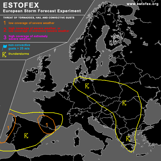
A threat level 1 is forecast across west coast of Portugal and Spain
A threat level 1 is forecast across extreme NE part of Spain and SW France
SYNOPSIS
Broad area of low geopotential heights with weak disturbances covers most parts of northern and eastern Europe... Broad area of low-end instability release can be expected over a broad area over eastern Europe...Cool mid level airmass should yield steepening lapse rates and development of widespread low-end instability, but weak shear should restrict the risk to marginal hail.
Main feature of interest will be a well developed trough west of Portugal, which slowly shifts towards the east, affecting most parts of SW Europe.
DISCUSSION
...west coast of Portugal and Spain...
Latest IR pictures already shows a cold front approaching the west coast of Portugal, which should cross th region during the morning hours... Conditions does not look favorable for any intense TSTM development along the coastal areas( presence of dry airmass, front starts attenuating trend and only marginal instability values).... Later on, this weakening front could produce enough forcing for the development of isolated to scattered TSTMs over central Spain, with an attendant risk for severe wind gusts/ isolated large hail ( very steep lapse rates and computed inverted-V forecast soundings )....Coverage will be too low for extending level 1 area further towards the east.
Concern about organized severe TSTM development over the level 1 area rises during the later afternoon and evening hours, when strong disturbance approaches the west coast of Portugal....Forecast sounding of La Coruna shows a strongly veered profiler, low LCL and release of at least low-end instability....Strengthening low level flow and forcing should help for scattered TSTM development in the level 1 area...Current thinking is that highest probabilities for isolated tornado development can be found along the coastal areas, where highest instability and 12m/s low level shear are forecasted to overlap...but also a few severe wind gust reports can be expected.
...extreme NE part of Spain and SW France...
Complex forecast unfolds for parts of SW France.
Models like GFS and NMM continue to forecast area of pressure fall over the level 1 region to start during the noon hours onwards and try to develop a closed low level circulation over the extreme SE part of the Bay of Biscay, moving onshore somehwere over SW France...Consistence of models (like GFS ) and favorable synoptic parameters ( like strengthening upper level divergence due to a well developed coupled jet structure )make this development pretty reasonable.
Main uncertainness will be strengthening WAA downstream of strong depression west of Portugal.... Modified soundings from this area show a pretty stout cap to develop over most parts of the level 1 area...Axis of ridging will cross SW France during the afternoon hours and mid-level cooling should extenuate capping.
Also difficult to pinpoint exact area of TSTM development, because of widespread forcing ( strengthening depression over the Bay of Biscay, slowly northward moving warm front and complex topography), but expect scattered TSTMs to develop during the late afternoon hours over extreme NE Spain / SW France.
Strength of developing depression will influence final position of warm front and size of warm sector ( lates thinking is that final position will be somehwere around the Bordeaux eastward ).
A negative factor will be that models, like GFS, indicate only weak instability signals( GFS up to 300 J/kg next to the depression )....Current thinking is that storms in the level 1 area will have an increased chance for being surface based.... TSTMs, developing straight south of the warm front or next to the depression will be also placed in an highly sheard environment....Broad area of backed wind is forecast to develop north and northeast of the depression ( causing SRH 1km values of about 300m^2/s^2 )and deep layer shear in excess of 25m/s... Each storm would pose a risk for tornadoes ( one or two strong ones )and severe wind gusts.... Furthermore, steepening lapse rates spread northward from Spain and should enhance a large hail risk with each storm.
Too many uncertainness still present that far out for an area with higher propabilities, but conditions could become favorable for a few significant storms to develop!
TSTMs should move towards the east/northeast with a continuing severe weather threat, although slowly weakening due to easing instability.
#