
STORM FORECAST
VALID Sun 02 Apr 06:00 - Mon 03 Apr 06:00 2006 (UTC)
ISSUED: 01 Apr 19:36 (UTC)
FORECASTER: GATZEN
SYNOPSIS
At the southern flank of long-wave trough over British Isles and northern North Sea region ... broad westerly flow is directed towards Europe ... and large delta flow pattern is present over eastern Europe. Embedded in the southern branch of the jet ... relatively weak vort-max/short-wave trough migrates eastward over northern Mediterranean ... reaching northwestern Balkans at the end of the period. To the north ... rather strong trough axis enters central Europe ... affecting North Sea region, France, and Germany. At lower levels ... temperate airmass is present over most of Europe, while cold maritime airmass remains over central and northern Scandinavia. Cool airmass is expected to spread into North Sea region, France and Germany NW of a cold front late the period.
DISCUSSION
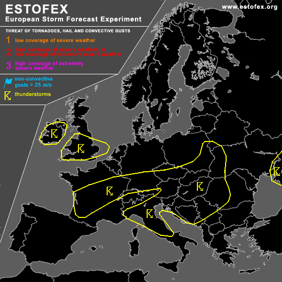
...Northern and central Italy, northern Adriatic, northern Balkans, eastern Poland and western Belarus
...
Rather warm airmass is present from Italy to northern Balkans ... characterized by relatively steep low-level lapse rates / inverted-v-profiles over Balkans / and rather shallow boundary-layer moisture. Models suggest that moderate instability will form in response to diurnal heating ... and expect that showers and thunderstorms to develop as upper vort-max / QG forcing approaches. Given weak vertical wind shear ... chance of organized severe convection is expected to be low. However ... locally enhanced CAPE may lead to short-lived but intense thunderstorms ... capable of producing isolated large hail and severe wind gusts.
...Central France and southern Germany/ Alpine region
...
South of a frontal boundary that moves into Germany and France during the period ... warm and slightly unstable airmass is forecast over central France and southern Germany. This airmass is characterized by steep low-level lapse rates and rather rich boundary layer moisture. Expect that showers and thunderstorms will develop in the warm sector of propagating frontal wave ... chance for organized convection seems to be low given weak vertical wind shear. Some hail and strong wind gusts should be the main threat.
#