STORM FORECAST
VALID Tue 28 Mar 06:00 - Wed 29 Mar 06:00 2006 (UTC)
ISSUED: 28 Mar 01:44 (UTC)
FORECASTER: VAN DER VELDE
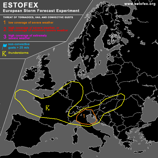
A threat level 1 is forecast across Northern Italy, Istria and Slovenia
SYNOPSIS
An Atlantic upper trough is moving into Europe, with most PVA and the jet between 42-46 N. North of the jet, modest instability will be present in the maritime airmass over France into the Benelux and Germany. The extent to which storms may form into those areas is somewhat uncertain, since the older NMM run forecasts instability more southward and eastward than the more recent GFS runs.
In the PVA/left jet exit zone a surface low deepens (12Z) and is progged by the various models to be right over N-Italy during the afternoon.
DISCUSSION
...N-Italy, Slovenia area...
Although GFS model comes with just a few gridpoints of a few hundred J/kg CAPE, the signal of developing instability at the approach of the upper trough is reflected also in the (convective) precip of GFS, NMM and MTG MM5/AFWA MM5. The area is at the nose of a 2-4 km model lapse rates plume apparently originating from Morocco. Low-level convergence will be concentrated into a small area in the warm airmass (~7 g/kg mixing ratio) that will be swept away by the advancing cold air after 18Z.
Northeastern Italy seems the area most favourable for storm development, as the cool Adriatic may possibly limit convection for the eastern part of the level 1 area. Due to strongly backed low-level winds, storm-relative helicity values are enhanced in GFS to over 250 m2/s2, while deep layer shear moderate to strong over 25 m/s. This setup is certainly capable of producing supercells or severe long-lived storms with a chance of large hail and severe gusts. Low-level shear amounts to 10-15 m/s over 0-1 km and can support tornadoes. At this moment, it seems uncertain how many storms would form ...tend to be on the careful side, expecting just one or two storms, due to marginal CAPE setup. However, it has occurred more often that models underforecast CAPE in this area (but in NW flow over the Alps).
...Hungary...
More in the east over Hungary and northwestern Romania GFS and NMM models develop some CAPE in a convergence zone/surface trough and theta-e plume, with good sr-helicity values, but the instability appears to develop around 18Z and later, with LFCs more than 1500m higher than LCLs, which makes elevated convection more likely than surface-based convection, and hence fairly low probability that severe storms develop. There seems too little synoptic support to keep things going.
#