STORM FORECAST - UPDATE
VALID Mon 27 Mar 14:00 - Tue 28 Mar 06:00 2006 (UTC)
ISSUED: 27 Mar 14:21 (UTC)
FORECASTER: TUSCHY/GROENEMEIJER
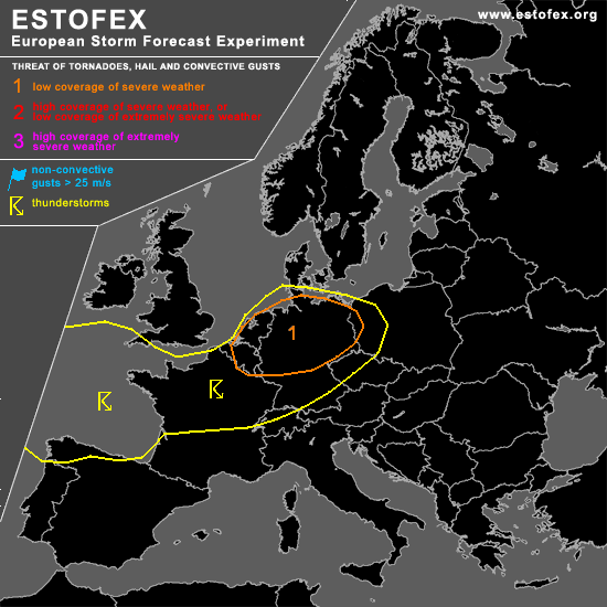
A threat level 1 is forecast across northern and western Germany, most of the Benelux countries and a part of northern France
SYNOPSIS
refer to the latest storm forecast
DISCUSSION
...Benelux, northern and western Germany, northern France...
12Z soundings show strong shear under the 500 hPa jet over northern and western France, the Benelux and into northern Germany. A couple of strong storms, some of which likely contain rotating updrafts, have developed over the Netherlands and Belgium and move into northwestern Germany. Other storms are present across Mecklenburg-Vorpommern.
In the next 3 hours, more storms are expected to develop across northern and central Germany, the Benelux and northern France. They will pose a continuing threat of large hail and gusts that may exceed the severe limit of 25 m/s. Some threat of tornadoes will exist where low-level winds have backed ahead of mesoscale troughs to produce rather high amounts of storm-relative helicity.
At this moment, relatively backed winds over central Niedersachsen and an ongoing supercell storm near Meppen indicate that an enhanced potential for tornadoes probably exists there as well. Additionally, pressure falls in a line rougly from Metz to Brussels, indicate that another trough with backed wind ahead of it may be forming.
Centre point of the convective activity is expected to translate southeastward during the evening. Decreasing values of instability will mean that the severe threat should decrease after sunset.
#