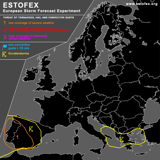
STORM FORECAST
VALID Fri 17 Mar 06:00 - Sat 18 Mar 06:00 2006 (UTC)
ISSUED: 16 Mar 20:59 (UTC)
FORECASTER: TUSCHY
A threat level 1 is forecast across Portugal and SW-central Spain
SYNOPSIS
During the past 24 hours, no significant change occurred regarding the European weather pattern.... Broad and well developed high pressure area north of Ireland will start a slow drift towards the west, but will be still strong enough for further advecting cool and stable airmass towards most parts of Europe.
Main area of interest will be the Mediterranean and SW Europe, where conditions look favorable for at least a marginal severe weather threat.
Strengthening depression will cross extreme northern Norway/Finland from west - east during the night hours and wind gusts could locally exceed severe-criteria, but wind field won't be compact enough for highlighting the area ATM.
DISCUSSION
...Portugal and SW-central Spain...
Although degree of TSTM evolution still uncertain due to a complex developing weather pattern, conditions look like to be favorable for at least a marginal severe weather threat in the highlighted areas.
Latest IR loops show a well developed upper level system west of Portugal with a broad sector of enhanced convection ( many SFLOC reports were also recieved from this area [ 00-19UTC, 16.March ]).... Also, loosely developed frontal system [ being placed over extreme NE Spain and Bay of Biscay ATM ]will modify into a slowly northward moving warm front, which would place most parts of Spain and Portugal into a broad warm sector.
Main feature of interest looks like to be a well developed jet ( ~120kt at H3 and 70kt + at H5 ), which rounds the base of the trough in a moment... Although system is nearly vertically stacked, models indicate a developing negative tilt of this system as a consequence of this jet... This displacement would bring the trough directly in front of the western Portugal coast during the latter part of the forecast period.
Although latest sounding from Lisbao [16.March 12Z]is showing a well developed elevated mixed layer over the area of interest, few ingredients will help for at least slight instability release... Advection of a more humid airmass in the H7 niveau towards the NNE, cooling of the mid-levels due to the approach of the trough axis and a tongue of high Theta-E's at the lower levels, which will be advected northward over the risk area.
Although isolated TSTMs can develop during the whole 24-hours time frame, main concentration of TSTMs is expected to develop during the afternoon-early evening hours, when weak front/confluence zone will reach Portugal and upper level divergence reaches its maximum due to the placement in the left exit region of approaching mid - level jet.
Enhanced LL shear ( up to 15m/s ) and strong helical low level flow along the frontal boundary should pose an enhanced risk for a few tornado and isolated wind gust reports....although shear will slowly ease in the postfrontal airmass, strengthening CAPE-field and lowering LCLs will pose a continuing threat for isolated tornadoes.
...central and eastern Mediterranean...
Broad area of enhanced TSTM development expected due to a vort. maximum, crossing the area during the afternoon hours onward...Cooling mid-levels and ~10°C SSTs will be enough for low-end instability release.... Main risk will be a severe wind gust threat ( DLS in the order of about 20-25m/s), but expected risk-coverage too marginal for warranting a level 1.
#