STORM FORECAST
VALID Fri 10 Mar 06:00 - Sat 11 Mar 06:00 2006 (UTC)
ISSUED: 09 Mar 20:54 (UTC)
FORECASTER: TUSCHY
SYNOPSIS
Deep wintry weather pattern continues over most parts of Europe... This will restrict the areal coverage for TSTM development to parts of central Europe... Otherwise, cool/cold and stable conditions will predominate.
Synoptic-wise, a well developed upper level trough, filled with cold mid-level air, will cross parts of central Europe during the forecast period, reaching eastern Poland/Hungary during the early morning hours on Saturday.
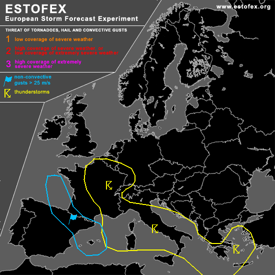
This eastward moving trough will help to create a strengthening baroclininc zone over western Europe...along this one, an intensifying disturbance will reach the Bay of Biscay during the noon hours, sliding towards the SSE...Models forecast a strengthening H85 jet, which will affect the coastal areas of northern Spain during the evening hours, reaching the Balearic Sea during the morning hours... Well mixed lower atmosphere [Santander ] and forecasted sounding winds of ~30m/s at H9 indicate that there will be an enhanced risk for widespread strong to isolated severe wind gusts in excess of 25-30m/s [ even stronger on exposed mountainous areas further inland ].
DISCUSSION
...most parts of France,western Germany, Ligurian Sea,Tyrrhenian Sea,Ionian Sea,Adriatic Sea and Aegean Sea...
Axis of upper-level trough slowly shifts towards the east during the next 24 hours... Core of very cold mid-level airmass [H5 < -35°C ]will cross a broad area [ north-cntrl / eastern France - Germany ]...Forecast soundings from this region show steep lapse rates and a pretty moist airmass... Expect scattered TSTMs to develop with a marginal hail risk in stronger TSTMs... Enhanced LL shear and low LCLs would also be favorable for a tornado report.
When cold mid-level airmass reaches the warm Mediterranean, widespread low-end instability release can be expected with accompanied scattered TSTM development over a broad area... LL shear is forecasted to be slightly enhanced mainly along the coastal areas and there could be one or two waterspout reports, but over-all threat seems too low ATM for issuing higher probabilities....
During the midnight hours, arriving disturbance is accompanied by strong vorticity advection and intense left exit region of impressive H3 160kt + jet will re-intensify TSTMs over the eastern Balearic sea although it's not clear, how far the storms will/can develop towards the west( which would be important for an enhanced severe wind gust risk )... Went with a TSTM area, because of too many uncertainness that far out of final strength and track of the disturbance.
During the early morning hours, TSTM coverage should also increase in the eastern part of the TSTM area due to cooling of the mid-levels and a weak vort-max, which will cross the area from SW towards the NE....again, a few severe wind gust and one or two waterspout reports can be expected from this area due to enhanced LL shear.
#