STORM FORECAST
VALID Mon 06 Mar 06:00 - Tue 07 Mar 06:00 2006 (UTC)
ISSUED: 06 Mar 01:14 (UTC)
FORECASTER: VAN DER VELDE
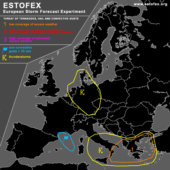
A threat level 1 is forecast across the southern Balkan and southeastern Italy, west coast of Turkey
SYNOPSIS
Low pressure areas near Denmark and Italy under an upper trough cause deep convective activity. The jetstream over the cold front at the east side of the Italian low generates kinematic conditions favourable for severe convective weather. A back-bent occlusion develops at the start of the forecast period with also some thunderous activity, though in less favourable shear conditions. Warm air advection ahead of the cold front creates ample storm-relative helicity due to the veering winds with altitude.
DISCUSSION
...portions of Italy, Albania, Greece, Macedonia, Bulgaria, Turkey...
with GFS and NMM models forecasting negative lifted indices, a marginal few hundred J/kg MLCAPE at most, and strong synoptic scale ascent, conditions for widespread thunderstorms will be present. Kinematic conditions in the form of deep layer shear over 30 m/s (0-6 km) and low-level shear over 10-15 m/s and SREH over 250 m/s in unstable airmass may very well induce rotating updrafts that could enhance potential for a few tornadoes and large hail events, and a bow-echo storm system may form parallel to the cold front with a particular chance of severe gusts.
...Benelux, Denmark, Germany...
In the maritime airmass convective elements may be slightly electrified and lightning may more or less happen sporadically all over the area. If some organisation occurs, associated with a trough, the chance may be enhanced. In the southwest part of the area, deep layer shear will be enhanced later in the period but convection will mostly have ceased by that time.
#