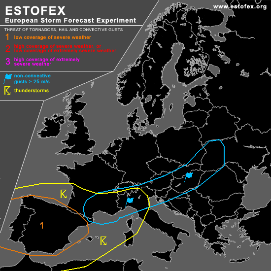

STORM FORECAST
VALID Sat 04 Mar 06:00 - Sun 05 Mar 06:00 2006 (UTC)
ISSUED: 03 Mar 17:10 (UTC)
FORECASTER: DAHL
A threat level 1 is forecast across the Iberian Peninsula.
SYNOPSIS
Broad and intense upper westerly flow is present over central and southern parts of Europe. Elongated vort max progged to reach the WRN Channel by Satuday 00Z is expected to phase with Atlanric vort max farther south ... the latter of which will overspread Iberia on Saturday and reach the W Mediterranean early Sunday morning. The northern vort max will cross central Europe and quickly move NEWD into NW Russia by the end of the period. Strong ... wavy low-level baroclinic zone is aligned zonally across central Europe ... with leading cyclone expected to move across E Europe into W Russia on Saturday. Downstream ... models development of wave lows ... with model solutions differing in intensity and position of these cyclones.
DISCUSSION
...Iberian Peninsula and WRN Mediterranean...
Indications are that air mass ahead of the Iberian upper trough will become weakly unstable during the day ... due mainly to low-level moisture advection and vertical motion. TSTM Coverage is somewhat uncertain ATTM ... but any SFC-based TSTM that forms will benefit from quite strong shear ... promoting 0-1 km SRH values in excess of 200 J/kg ... so that a small ... possibly tornadic ... supercell or two could occur. Also ... marginally severe wind gusts could accompany the strongest cells. Though models do not all converge towards this solution ... confidence in at least scattered convective development is high enough for a level one threat. TSTMS may continue until late Saturday night well into the N Mediterranean ... but model solutions are too incoherent for a categorical risk. An upgrade may be required for the NW Mediterranean and N Italy if thermodynamic fields are stronger than currently anticipated and if GFS' solution with respect to the position/intensity of frontal wave verifies.
An isolated CG or two may also occur farther downstream along and S of the main frontal boundary over ... S Germany and the extreme N Balkans into the W Ukraine and the Belarus. Indications are that this activity will be very isolated ... not warranting a TSTM forecast. However ... this activity could augment the already strong/severe mesoscale wind fields associated with the wave lows.
...North-central and NRN Europe...
N of the frontal boundary ... polar air mass with impressively steep lapse rates is in place ... which are associated with cellular convection. This convection will likely exist throughout the period ... though it should not produce much lightning ... and a TSTM forecast is not necessary for this activity.
#