STORM FORECAST
VALID Fri 03 Mar 06:00 - Sat 04 Mar 06:00 2006 (UTC)
ISSUED: 02 Mar 21:22 (UTC)
FORECASTER: TUSCHY
SYNOPSIS
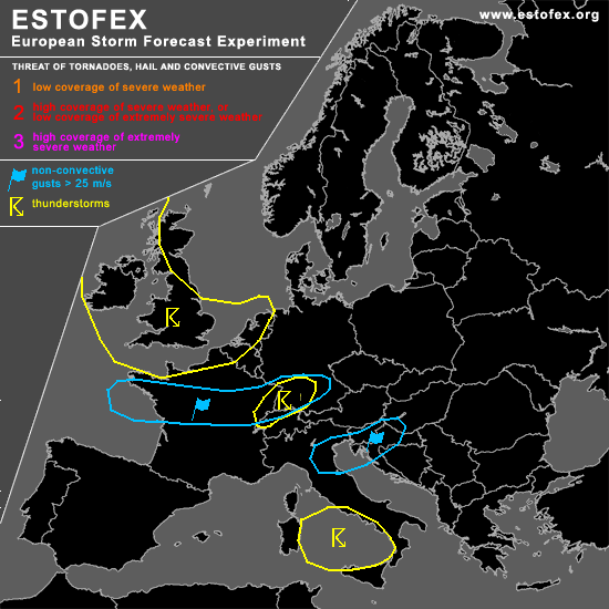
The weather pattern over Europe is marked by an impressive pool of cold airmass over northern / eastern Europe and warm air over the Mediterranean... Well developed zonal flow will be present over central Europe, where multiple low level depressions will race from west towards the east with an enhanced threat for widespread severe-damaging wind gusts!
Strongest wind gusts will develop over western-central France along strengthening cold front during the early afternoon hours, reaching southern Germany during the later evening/early night hours.
A second severe wind gust field will develop south/southeast of the Alpes during the night hours, moving further towards the east.
Broad and weakly developed trough will cross the western Mediterranean during the forecast period, but instability / kinematic parameters will be too low/weak for any expected organized TSTMs ATM.
DISCUSSION
...Parts of Switzerland, SW Germany and eastern France...
Even now, the exact track of rapidly intensifying low level depression is afflicted with uncertainness, but at the moment it looks like that models slowly agree in a track over central France - southern Germany.
Conditions will be favorable for a developing intense depression in the left exit region of outstanding 160kt + H3 jet and an intense baroclinic zone over north - central France...Models indicate the arrival of a well developed cold front during the early night hours over France and SW Germany... A tongue of moderate Theta values will be advected towards the northeast and will cover the area of interest....this can also be seen on the forecast sounding of Zürich, which showes a humid prefrontal airmass.... This airmass, the arriving intense upper level divergence, eastward pushing cold front and topography would all favor the development of at least a few electrified TSTMs over the Black Forest/Jura region eastward....Deep layer shear of 45m/s and signals in the model charts of a well developed 35m/s+ H85 jet core over SW Germany will pose a significant threat for severe - damaging wind gusts with each stronger shower/TSTM.
...Ireland and United Kingdom...
Expect a broad area [ North Sea - English Channel - United Kingdom and Ireland ]where TSTMs can develop.
Upper-level trough with extremely cold air [ ~ -40°C at H5 ]was present on lates IR loops [20UTC] over northern parts of United Kingdom....marked by a broad area of enhanced cumulus cloud development with cold cloud tops.... This trough will slide southward during the next 24 hours, reaching the French mainland during the night hours... Steep lapse rates will be present in the area of interest and up to 300 J/kg SBCAPE offshore can be expected, mainly west of United Kingdom, where SST up to 9°C create high Δ T's [ surface - H5 ]....Slightly enhanced SRH1 values will be present over Ireland with a marginal hail risk threat, but over-all weak wind shear precludes me for issuing a level 1.
#