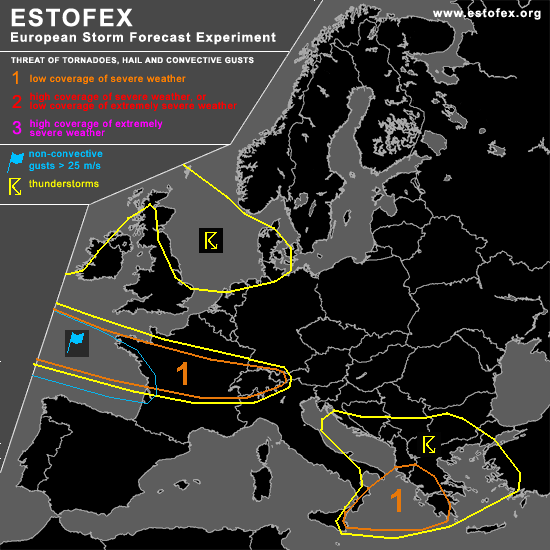

STORM FORECAST
VALID Thu 02 Mar 06:00 - Fri 03 Mar 06:00 2006 (UTC)
ISSUED: 02 Mar 06:51 (UTC)
FORECASTER: GATZEN
SYNOPSIS
Arctic trough present over Europe is centered over North Sea region and northern Germany. At its periphery ... a vort-max/short-wave trough travels eastward over northern Mediterranean ... reaching Black Sea region at the end of the period. South of this vort-max ... strong jet streak will enter southern and eastern Mediterranean. Another strong vort-max will affect France late in the period. Both vort-maxima will be associated with strong QG forcing ... and latest model output shows deepening surface low pressure systems over Black Sea and northeastern France at the end of the period. At lower levels ... cold arctic airmass has spread over most of Europe and western Mediterranean ... while warm airmass will be present over eastern Mediterranean ahead of approaching vort-max.
DISCUSSION
...Central and eastern Mediterranean
...
Relatively warm airmass is present from central to eastern Mediterranean
.. characterized by steep low-level lapse rates and relatively rich
low-level moisture as indicated by latest ascends. During the period ... strong QG forcing is expected
at the northern flank of approaching jet streak ... and latest model
output shows that significant instability will form in the warm sector
of deepening surface low pressure system. Along and ahead of the cold
front ... showers and thunderstorms will likely develop reaching western
Greece in the afternoon. Given strong vertical wind shear ... organized
convection seems to be likely ... and multicells and embedded
mesocyclones are forecast ... capable of producing large hail and severe
wind gusts. A tornado or two is not ruled out given enhanced low-level
helicity. To the north ... polar airmass has destabilized over Adriatic region. In the range of the upper trough ... thunderstorms are expected to go on. Given nehanced vertical wind shear ... isolated severe events are expected ... and a tornado is not ruled out.
...France...
Late in the period ... strong vort-max enters France ... and strong
surface low pressure system is expected to develop. South of the low ...
warm sector airmass will be moist and characterized by neutral or
slightly unstable lapse rates. Along the approaching cold front and
following vort-maxima ... strong QG forcing will be likely ... helping
showers and thunderstorms to develop. Given very strong vertical wind
shear ... chance for embedded tornadoes should be enhanced. Most
significant severe threat should be severe wind gusts in the range of
strong pressure gradient.
#