STORM FORECAST
VALID Tue 28 Feb 10:00 - Wed 01 Feb 06:00 2006 (UTC)
ISSUED: 28 Feb 10:51 (UTC)
FORECASTER: GROENEMEIJER
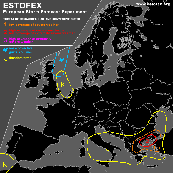
A threat level 2 is forecast across parts of Greece, Turkey, southern Bulgaria
A threat level 1 is forecast across an area surrounding the level 1 area
SYNOPSIS
refer to convective forecast
DISCUSSION
...Greece, Turkey, southern Bulgaria...
Rapid destabilisation appears to be occurring across the Aegean Sea area as the strong low-level jet transports moisture quickly northward while mid-tropospheric temperatures should be dropping accorsding to model guidance. SBCAPE values of 500-1000 J/kg appear likely across the northern Aegean Sea and northern Greece, with most of the buoyancy being present at very low altitudes. This, in combination with very strong low-level shear and an estimated 200-300 m2/s2 of 0-1 km SRH being present ahead of a cold front analyzed along a line from central Crete to just west of Thessaloniki at 10 UTC. The front is mainly characterized by a wind shift and drop in moisture.
The favourable buoyancy and shear parameters should allow some of the storms (that aredeveloping across the western Greek mainland and Pelopnnesos as well as the western Aegean Sea) to develop into supercells, that have the capability to produce a few tornadoes, -which may be strong- as well as a severe gusts and large hail.
Hence, an upgrade for the area that will likely be affected by the storms seems to be warranted.
#