STORM FORECAST
VALID Tue 28 Feb 06:00 - Wed 01 Feb 06:00 2006 (UTC)
ISSUED: 27 Feb 23:46 (UTC)
FORECASTER: GROENEMEIJER
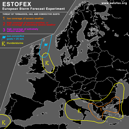
A threat level 1 is forecast across parts of Greece, Albania, Turkey and Bulgaria.
SYNOPSIS
Tuesday at 06 UTC... a large low pressure area over northern Scandinavia dominates the weather maps of the mid-troposphere. On its western flank, an maritime arctic air mass works its way southward over the UK and the North Sea into western continental Europe. Over the Mediterranean, the most domiant feature is a low over southern Italy that moves east-northeastward.
DISCUSSION
...Albania, Greece, Bulgaria, Turkey...
A quite powerful MCS is expected to be reaching the Albanian and Greek coasts of the Ionean Sea and the southern Adriatic at the beginning of the period. Related with the system, wind gusts reaching severe levels are expected to occur in some places. Given the srong shear profiles and highly helical flow expected ahead of the MCS, it is not ruled out that rotating updrafts/mesocyclones develop that yield a small threat of tornadoes and enhance the chance of some hail > 2 cm.
An area of strong warm air advection is expected to develop across the Aegean on Tuesday morning as the mid/upper dsturbance moves east-northeastward. This, in combination with rising motions forced by differential vorticity advection should result in rather strong upward motion in the mid-troposphere. As a consequence, rapid steepening of the low-level lapse rates is expected and a few 100s of J/kg CAPE should be able to develop.
GFS suggests that a new low pressure area will develop across the northern Aegean Sea and a broad warm frontal precipitation shield will move northeastward from the Aegean Sea into Bulgaria and Romania during the day and evening. Near the surface warm front... that should move northward from the northern Aegean into southeastern Bulgaria... convective storms are expected to develop, which may well become surface-based near and south of the front.
As 0-1 km shear will be very strong in the exit of the forecast 30 m/s low-level jet and 0-1 storm-relative helicity may well exceed 300 m2/s2, a few -possibly tornadic- supercells may develop. The optimal combination of shear and buoyancy parameters appears to be over north-central Greece in the late morning and northeastern Greece, adjacent parts of southern Bulgaria and northwestern Turkey in the afternoon. An upgrade to level 2 for parts of these areas may be issued on Tuesday morning or afternoon.
#