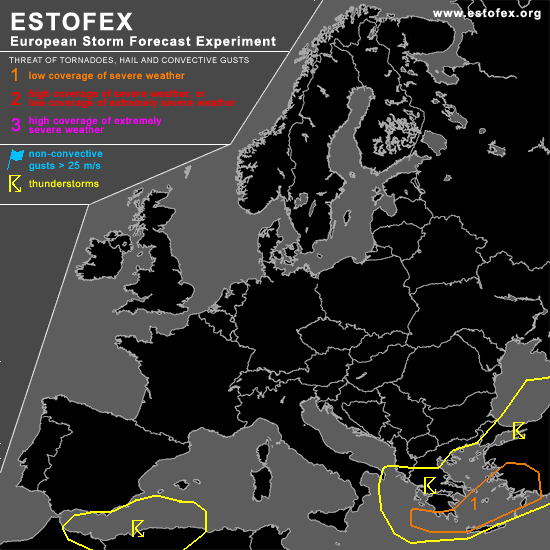

STORM FORECAST
VALID Sun 26 Feb 06:00 - Mon 27 Feb 06:00 2006 (UTC)
ISSUED: 25 Feb 14:22 (UTC)
FORECASTER: DAHL
A threat level 1 is forecast across the southern Aegean region and south Greece.
SYNOPSIS
Upper vort max expected over the Ionian Sea by the beginning of the period is progged to cross the Aegean Sea and leave the forecast area via Turkey late in the day. Intense upper cut-off cyclone forecast over Iberia Sunday midday should continue SEWD track reaching N Algeria late Sunday night. Associated SFC low will likewise move SE and reach the SW Mediterranean by the end of the forecast period.
DISCUSSION
...SW Mediterranean...
Instability in the warm-sector of the SW Mediterranean low is a bit of a source of uncertainty ATTM ... current lack of lightning activity with this system may be symptomatic of an overestimation of the CAPE by the models. In addition ... given that there are only weak signals in the model CAPE fields for Sunday ... chances of widespread TSTM development seem to be rather low. Better chances exist in the postfrontal environment beneath the upper thermal-low in the late evening hours. Weak shear suggests that degree of strom organization will be low ... though a brief waterspout or two could occur.
...S Greece ... S Aegean Sea ... SW Turkey...
TSTMS should exist over the Aegean Sea and W Turkey in weakly unstable air mass. Deep shear of 20 to 30 m/s is expected over S Greece the S Aegean region and SW Turkey ... and isolated mesocyclones and small/short-lived bow echoes may occur. LL shear should be enhanced along coastal areas due to enhanced friction ... and a tornado or two could occur. Main severe threat should be marginally severe outflow wind gusts and large hail though. Threat should diminish after about 18 to 20Z.
#