STORM FORECAST
VALID Fri 24 Feb 06:00 - Sat 25 Feb 06:00 2006 (UTC)
ISSUED: 23 Feb 18:31 (UTC)
FORECASTER: TUSCHY
SYNOPSIS
Broad trough will be placed over most parts of central/southern Europe and attendant cool and stable airmass covers most parts of Europe, which will only permit a few TSTM areas to develop...Intense high over low blocking helps for further continuation of the all-over disturbed weather pattern.
An outbreak of arctic air will start to affect the northern areas of Europe during the next 24 hours.
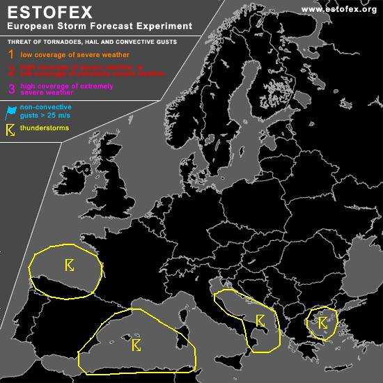
DISCUSSION
...Adriatic Sea...
Weakening depression will slowly move towards the north/northwest, crossing the Adriatic Sea from south to north with attendant pool of cool mid-level airmass... This will help for widespread low-end instability release, but don't expect any significant values [gradually warming of the atmosphere from the south should weaken the lapse rates ]...Enhanced LL shear and SRH1 values [ ~ 200m**2/s**2 ] will pose a risk for a few waterspouts along the coastal areas, but expected coverage will be too marginal for warranting any threat level ATM.
...Bay of Biskay...
Models agree in path of depression, moving over the Bay of Biskay from the NNE-SSW, reaching the coastal areas of northern Spain during the early night hours...Widespread instability release forecasted and expect scattered TSTMs to develop during the day over the Bay...As the system approaches the coast, LL shear increases and there will be the risk for one or two short-lived tornadoes and marginal hail reports.
Southeastward spreading cold mid-level airmass will help to generate many TSTMs between Sardinia and Spain...Lack of shear should preclude any organized TSTM development.
Also don't want to exclude the possibility for a few TSTMs to develop over the mountainous region of Spain, but coverage and risk ( mainly marginal hail ) prevent me to include this area into the TSTM line.
#