STORM FORECAST
VALID Thu 23 Feb 06:00 - Fri 24 Feb 06:00 2006 (UTC)
ISSUED: 22 Feb 18:16 (UTC)
FORECASTER: TUSCHY
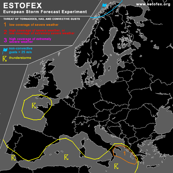
A threat level 1 is forecast across extreme SE Italy and the coastal areas of Albania and Greece
SYNOPSIS
Highly disturbed weather pattern continues to evolve over Europe....A broad trough continues to broaden and amplify slightly to the south ( even covering most parts of northern Africa) as a consequence of rising pressure around Iceland... Cyclogenesis seems to be favorable along the strengthening baroclininc zone over SW and SE Europe and main convective activity will be expected with those depressions.
A stormy and active weather period will be also evident over northern Norway/Sweden and arriving cold front during the night hours should yield an high potential for severe-damaging wind gusts during the night hours [ 30-40m/s along coastal and exposed areas ].
DISCUSSION
...extreme SE Italy and the coastal areas of Albania and Greece...
Models seem to have a pretty good handling on developing depression over Algeria/Tunisia, moving slowly towards the NE and reaching Sicily during the morning hours and the coastal areas of Albania during the early night hours... Surface observations of Tunisia show regressing surface pressure and values of about 1006hPa [ at 16UTC ], which agrees pretty well with latest model runs (like GFS )... Conditions also look very favorable for an intensifying depression, with well developed dry slot pointing towards the depression and intensifying UL divergence due to a developing coupled jet structure... Depression will level off somewhere SE of Sicily with a minimum pressure of ~ 990hPa... MTG-GFS also shows a well developed slope between LL and UL depression....this means that conditions look favorable for widespread TSTM initiation between Tunisia and Albania.
Forecasted instability values of 500-700 J/kg SBCAPE look reasonable due to continued cooling in the mid-levels over a ~13°C warm Mediterranean.... Best instability can be found under the base of the depression with strongest wind fields well seperated/placed towards the east... Widepread TSTM development/storm clustering can be expected over Sicily with gusty winds... conditions will be also favorable for one or two waterspout reports....
A weather configuration, more beneficial for organized severe weather should develop during the evening hours over the level 1 area... Eastward placed UL cold pool in the mid levels will help to disequilibrate a broad area in the NE quadrant of the surface depression.... Arriving back bent front should yield enough forcing for scattered TSTM development in an environment with enhanced LL shear and SRH1 values ( ~ 150m**2/s** )...Modification of the wind field along the coastal areas should also enhance shear values with an attendant risk for one or two tornadoes and a few severe wind gust reports.
...extreme southern Portugal and Spain...
Models agree that a weak disturbance will approach SW Europe, reaching the area of interest during the afternoon hours... Uncertainness exists about exact strength of the system and if it will stay a closed low-level depression or will start to transform into an open wave during the approach.... This will be an important factor how far inland the warm front can be advected and how strong the shear finally will be... Current thinking is that depression will continue to weaken in the left rear quadrant of departing UL jet... Enhanced instability forecasted to be present along the coastal areas of SW Portugal and Spain in an environment with significantly enhanced LL and DLS shear....any developing storm will be capable of producing severe wind gusts and an isolated tornado...don't want to issue a level 1 ATM because of the depression's weakening trend and the uncertainty of the model pool.
#