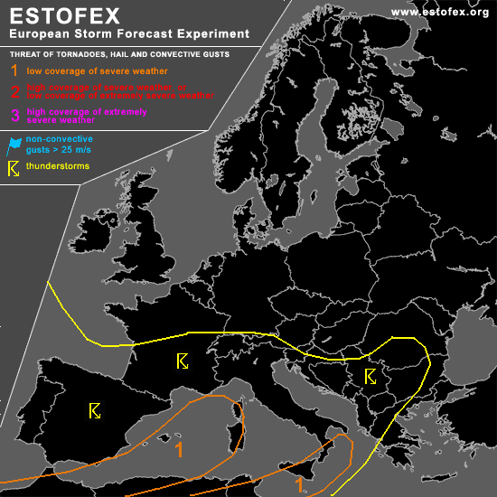

STORM FORECAST
VALID Wed 22 Feb 06:00 - Thu 23 Feb 06:00 2006 (UTC)
ISSUED: 21 Feb 19:19 (UTC)
FORECASTER: GATZEN
A threat level 1 is forecast across western and central Mediterranean
SYNOPSIS
Long-wave trough extends from Scandianvia to Iberian Peninsula. To the east ... SWerly flow affects Mediterranean and southeastern Europe.
DISCUSSION
...Northern Africa, Mediterranean...
Large and amplified long-wave trough extending over Europe ... with an axis from eastern Scandinavia to Germany and further to Iberian Peninsula. At its eastern flank ... strong upper SWerly jet affects western, and central Mediterranean. At the southern edge of this trough ... mean vort-max will travel over Algeria ... where intense upper short-wave trough will lead to strong QG forcing. Stong cyclogenesis is expected to develop over the Atlas mountains ... and warm airmass spreads into Tunisia ... where severe thunderstorms are expected to form during the period. To the north ... a couple of vort-maxima embedded in the upper flow will also travel northeastwards over Mediterranean ... providing DCVA. At lower levels ... steep lapse rates have formed over most of western, and central Mediterranean. Additionally ... boundary layer moisture has increased locally ... creating CAPE of several 100 J/kg as indicated by latest soundings. On Wednesday ... expect that thunderstorms will likely go on over the Mediterranean Sea given low-level CAPE, weak CIN, neutral lapse rates up to 500 hPa or less, and QG forcing. Thunderstorms that form may be well-organized given strong DLS in the range of the upper jet stream from Algeria to Italy ... and a few multicells and supercells are expected to develop ... capable of producing severe wind gusts and isolated large hail. The chance for tornadoes is also enhanced given low-level CAPE and locally enhanced low-level helicity values. Late in the period ... strong African vort-max will affect southern Mediterranean ... where models show CAPE up to 1000 J/kg and strong veering winds. However ... expect quite stable low-levels ATTM ... and chance for severe thunderstorms should be not too high.
#