
STORM FORECAST
VALID Fri 17 Feb 06:00 - Sat 18 Feb 06:00 2006 (UTC)
ISSUED: 16 Feb 22:37 (UTC)
FORECASTER: DAHL
SYNOPSIS
Broad and intense meandering zonal upper frontal zone is covering southern and central Europe. Extensive quasi-stationary SFC low centered S of Iceland over the N Atlantic... is extending far into the European continent ... affecting also S and SE Europe. Main low level frontal boundary over central/southern Europe is rather broad/diffuse ... with several wave-like perturbations along it ahead of the various vort maxima imbedded in the upper zonal flow.
DISCUSSION
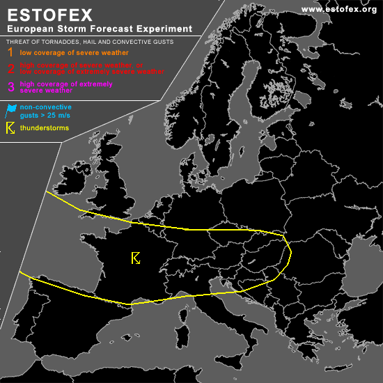
...south-central and western Europe...
Extensive area of cellular convection is present over the E Atlantic ... this activity should be enhanced ahead of the various vort maxima ... so that several regions of enhanced Cu's/Cb's and lines of shallow convection are anticipated. Strong DCVA regime overspreading France late in the period appears to be most promonent feature to support one or several lines of convection ... though bad timing may limit convective threat with this activity ... especially away from the coasts. General uncertainty exists on how far inland convective activity can survive ... but given mid-February south-central European insolation ... scattered TSTMS may still occur as far east as the north Balkans ... though likely not as widespread as farther west over France.
Especially over France ... quite strong shear profiles will be in place ... and especially if linear organization of the storms can be achieved ... a few wind gusts briefly/isolated reaching severe limits may occur. Also ... a shallow mesocyclone or two with an attendant hail/tornado threat cannot be discounted. But ... lack of focused low-level forcing for ascent and bad timing of French vort max preclude categorical threat ATTM. However ... an upgrade may be necessary if convection organizes better than currently anticipated.
#