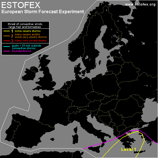

STORM FORECAST
VALID Sun 05 Feb 06:00 - Mon 06 Feb 06:00 2006 (UTC)
ISSUED: 04 Feb 18:15 (UTC)
FORECASTER: DAHL
A threat level 1 is forecast across the Ionian Sea ... Greece and the Aegean Sea.
SYNOPSIS
Not much of a change in the upper pattern expected ... large-scale upper low remains anchored over NW Russia ... covering most of E Europe and the central Mediterranean. Weak upper low centers/vort maxima ... gradually merging with the large-scale feature are present over the W Mediterranean. One such vort max will cross the Ionian Sea ... Greece and the Aegean on Sunday ... and should be the main focus for the development of deep convection. Weak SFC low is accompanying this feature ... and will likewise move from the central Mediterranean into western Turkey by early Monday morning. Otherwise ... stable thermodynamic profiles persist throughout the forecast area.
DISCUSSION
...Ionian Sea ... Greece ... Aegean Sea...
Vort max moving into the S-central Mediterranean on Saturday night ... and across the Ionian See and Greece on Sunday ... should be focus for potentially severe evolution. CAPE should be on the order of a few hundred J/kg ... and deep shear of about 20 m/s. However ... as pressures fall ahead of the vort max over Aegean region late in the day and during the evening hours ... low-level shear should become intense enough to support an isolated mesocyclones or two ... with an attendant hail/wind/tornado threat. If a line of TSTMS can be maintained ... it may feature short-lived/small bow echoes capable of briefly promoting a few marginally severe wind gusts. Extent of severe is somewhat uncertain ATTM as degree of CAPE is quite low ... and storms may not make it as far north as into Greece and the Aegean Sea. Given rather ample large-scale forcing for ascent and increasing deep shear however ... a level one threat is marginally warranted.
#