
CONVECTIVE FORECAST
VALID Sun 29 Jan 06:00 - Mon 30 Jan 06:00 2006 (UTC)
ISSUED: 28 Jan 19:59 (UTC)
FORECASTER: DAHL
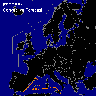
Thunderstorms are forecast across the SW and S-central Mediterranean Sea.
SYNOPSIS
High-over low block continues over Europe ... with vort max at E periphery of intense SW European upper low overspreading the S-central Mediterranean Sea towards the end of the forecast period ... accompanied by weak SFC cyclogenesis. Associated LL WAA regime should be one focus for convective development late in the FCST period. Otherwise ... hostile convective environment will persist across most of Europe.
DISCUSSION
...SW Mediterranean...
Models show inconsistent and weak signs of development of weak/shallow CAPE over the W Mediterranean ahead of cold-frontal boundary associated with the SW Euorpean upper low. There seem to be two foci for convective evolution on Sunday ... on is associated with weak frontal wave expected over the NRN parts of the W Mediterranean on Sunday morning ... and which should weaken towards early afternoon. Another focus should exist with plume of warm/moist air advecting into the S-central Mediterranean late in the period. Though latest GFS has reduced depth of convection in the latest run ... will introduce a TSTM area over this region.
Low level flow should be moderately strong in the latter regime ... but anticipated elevated nature of convection ... and reduced SFC friction over the water should limit magnitude of SRH in the inflow. Deep shear will likewise be only moderate ... and organized severe threat should be rather low. However ... an isolated waterspout or two cannot be ruled out.
Widely scattered CGs may occur with posfrontal convection near upper thermal low near the Iberian W coast ... but activity should remain too isolated for a TSTM forecast.
#