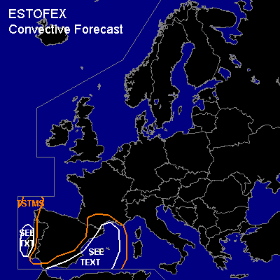

CONVECTIVE FORECAST
VALID Sat 28 Jan 06:00 - Sun 29 Jan 06:00 2006 (UTC)
ISSUED: 27 Jan 18:46 (UTC)
FORECASTER: DAHL
Thunderstorms are forecast across the SW Mediterranean and along the Iberian W coast.
SYNOPSIS
Upper blocking should persist through this period ... with French upper cut-off low expected to merge with EWD progressing Atlantic upper low ... resulting in large/intense cut-off cyclone by the beginning of the period. SFC low associated with the Atlantic system will move into the W Mediterranean and weaken somewhat. Strong cold frontal boundary associated with this system is expected to stretch parallel to Iberian E coast on Saturday morning and surge eastwards into the Balearic Sea during the day/evening.
DISCUSSION
...W Mediterranean...
Air mass ahead of the Mediterranean cold front will likely tend to be rather stable ... with neutral lapse rates being the best that can be expected. GFS doesn't simulate any deep MLCAPE while NMM ... allowing less mixing of the ascending parcels ... does show weak signals over the W Mediterranean in the immediate vicinity to the front. Given Friday's TSTM activity - albeit sporadic - it seems unlikely that no TSTMS will develop on Saturday given LL warm/moist advection and increasing large-scale forcing for ascent. Best chances for a few TSTMS should exist along and ahead of the front over the W Mediterranean. Rather vigorous low/mid level flow may support briefly organized storms ... which may be capable of marginally severe hail. Also ... low LCLs and strong low-level shear may promote a brief tornado. As models seem to converge towards rather stable convective environment ... allover threat should be rather low ... and a SLGT is not warranted ATTM.
Isolated CGs may occur also across the Ionian and Adriatic Seas in association with shallow convection ... lightning activity should be too isolated for a separate TSTM area, however.
...W Iberian Peninsula...
Shallow cellular convection should be able to form at the W periphery of the upper low ahead of a vor max late in the evening ... and may become just deep enough for isolated to scattered lightning strikes. Also ... shear will be rather strong especially along the coast where SFC stress will be increased ... which will be augmented by falling pressures and isoallobarically backed SFC winds. Though mesoscale organization should be rather weak ... an isolated shallow mesocyclone producing some marginally severe hail and maybe a brief tornado cannot be ruled out. However ... threat is very marginal.
#