CONVECTIVE FORECAST
VALID Sun 22 Jan 06:00 - Mon 23 Jan 06:00 2006 (UTC)
ISSUED: 21 Jan 17:44 (UTC)
FORECASTER: TUSCHY
There is a slight risk of severe thunderstorms forecast across parts of SE Mediterranean
Thunderstorms are forecast across Sicily eastward
SYNOPSIS
Impressive winter weather pattern persists over most parts of Europe during the next 24 hours...Very cold airmass, placed over most parts of eastern Europe during the past few days, slowly flows further to the west/southwest, now reaching eastern Germany/Austria....
At the same time, western and northwestern Europe will see stable conditions under the strong east-Atlantic ridge... Don't expect any organized convection to develop in those areas.
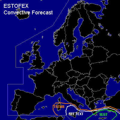
There will be only one region, where conditions look favorable for TSTM development [-> Sicilia eastward ], when well-defined upper-level system will move NE-ward over the warm waters of the Mediterranean... Models indicate developing LL depression east of this system, which will be the focus for a few organized storms.
DISCUSSION
...parts of SE Mediterranean...
Early evening IR loop [ 21.01.06 ] finally showed the eastward shift of upper-level low pressure area ( over Tunisia )... Interesting to note that models indicate a weaker system to cross the Mediterranean ( compared to yesterday runs )... Model pool pretty consistent in showing a trend toward an occluded extratropical system and H5 spaghetti plot[MTG-GFS] even loses this system for a short period of time... Despite this weakening trend, models still indicate the development of a 1008hPa LL depression east of Malta, which will race pretty fast towards the NE, passing extreme southern Greece in the early evening hours, reaching the SW coast of Turkey during the early night hours [ ~ 1004hPa]...
Models indicate that ~ 500 J/kg SBCAPE will be possible during the passage of the depression between Greece and Crete.... Enhanced LL shear / SRH values over extreme southern Greece will pose a risk for a few organized storms with a severe wind gust / tornado report possible.
Later on, same conditions will exist over SW Turkey, although models like GFS indicate the chance for a developing backing wind field and therefore impressive SRH values... Not sure how far inland the TSTMs will develop, but I doubt that storms will root into the cool and stable boundary layer over most parts of western Turkey...so becoming pretty fast elevated....Main risk for a few severe wind gust reports and one or two tornadoes should be confined along the coastal areas of extreme SW Turkey.
...Sicily eastward...
Trough axis will shift SSE-ward over the central Mediterranean during the forecast period, producing widespread destabilisation, but best thermodynamic/kinematic fields will be well seperated... Main area of interest will be the SEE TEXT area north and east of Sicily, where models indicate an overlap of ~ 200J/kg SBCAPE and up to 30m/s DLS... Current thinking is that shallow, electrified TSTMS will develop in this area during the evening hours... Forecasted EL heights of 3km would indicate that storms would only get a fraction of the available DLS, but area will be monitored for stronger cell development and hence a westward extent of the SLGT risk area....Forecast sounding of Sicily denotes steep LL lapse rates, some instability in the low levels and weak shear, which is favorable for a few waterspouts to develop.
#