CONVECTIVE FORECAST
VALID Sat 21 Jan 06:00 - Sun 22 Jan 06:00 2006 (UTC)
ISSUED: 20 Jan 18:47 (UTC)
FORECASTER: TUSCHY
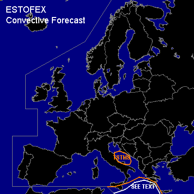
Thunderstorms are forecast across Malta, SE Sicilia and the Ionian Sea
SYNOPSIS
Pool of very-extremely cold air now runs from S-Norway southeastward towards the Ukraine... Strong depression will shift southeastward along this strong baroclinic zone, gradually weaken during the next 24 hours...
CNTRL/NE Germany will be in the path of this system and models indicate some low-end instability....However... current thinking is that there will be only the chance for an isolated, weakly electrified TSTM in areas, where updrafts may get local support by topographic effects, with a risk for gusty winds, but coverage too marginal for warranting any highlighted areas ATM...
Cold mid-level airmass will arrive over 13-14°C warm Adriatic sea and enough instability should develop for a few shallow TSTMs... 25m/s DLS will be present with attendant severe risk gust threat, but threat too marginal for issuing a risk area.
Most parts of western Europe will be affected by rising geopotential heights due to a slowly ENE-ward shifting ridge over the extreme eastern Atlantic Ocean.
Main feature of interest will be a well defined upper-level low pressure ( still be placed over eastern Algeria ), which should slowly accelerate to the northeast, reaching the Mediterranean somewhere south of Malta.
DISCUSSION
...Malta, SE Sicilia and the Ionian Sea...
Upper-level system is forecasted to reach the Mediterranean during the evening hours, but LL depression will develop 6 - 9 hours earlier along the eastern coast of Tunisia... GFS forecasts ~500 J/kg SBCAPE in this area and this looks reasonable (SST 15-17°C and mid-levels, which will cool down )...Expect scattered to widespread TSTM development in th SEE TEXT area... Severe weather threat should be limited because of well seperated thermodynamic/kinematic areas.
#