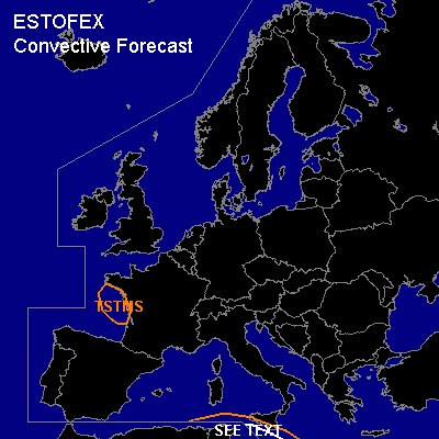

CONVECTIVE FORECAST
VALID Sun 08 Jan 06:00 - Mon 09 Jan 06:00 2006 (UTC)
ISSUED: 07 Jan 18:54 (UTC)
FORECASTER: DAHL
Thunderstorms are forecast across the western Gulf of Biscay and the adjacent coast.
Thunderstorms are forecast across the south-central Mediterranean Sea.
SYNOPSIS
Two upper cut-off lows ... one moving from the British Isles into the Gulf of Biscay ... and the other moving from N Algeria into the south-central Mediterranean Sea ... will be potential foci for convective evolution this period with extensive upper high ... centered over NE Europe ... maintaining unfavorable thermodynamic environment for deep convection over the rest of the forecast area.
DISCUSSION
...W Gulf of Biscay...
Rather shallow convection ... producing isolated to scattered TSTMS ... should develop beneath upper cold pool associated with the British cut-off cyclone over the E Gulf of Biscay and portions of the French W coast towards early Monday morning.
...S-central Mediterranean...
Better chances for more widespread TSTMS seem to exist ahead of vort max at the E periphery of the Algerian upper low which will affect the S-central Mediterranean late in the period. Instability will likely be rather weak ... and possibly elevated given strong WAA contribution ... so that effective shear magnitude may be rather weak as well. Those cells that manage of tap BL air/helicity will have some potential to become severe ... main threat being marginally severe hail and maybe a brief tornado. Allover threat seems to be too low for a SLGT.
Isolated lighthning may occur also over the W Mediterranean where weak/shallow CAPE may persist but lack of large-scale forcing for ascent suggests that any lightning will be too sporadic for a TSTM area.
#