CONVECTIVE FORECAST
VALID Fri 06 Jan 06:00 - Sat 07 Jan 06:00 2006 (UTC)
ISSUED: 05 Jan 21:11 (UTC)
FORECASTER: TUSCHY
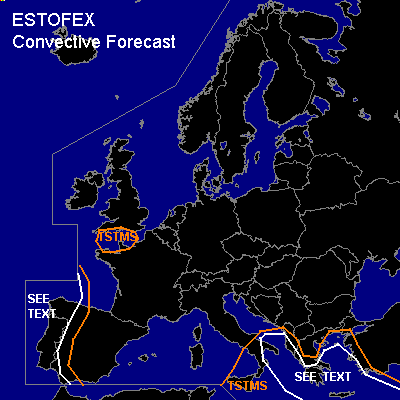
Thunderstorms are forecast across parts of the central and eastern Mediterranean, western Iberia and across the English Channel
SYNOPSIS
Well developed high pressure area present over most
parts of northern Europe... Cool and stable airmass will suppress any
convective activity.
Main area of interest will be a southward dropping
depression over SW Europe, reaching extreme NW Africa during the late
afternoon hours.... Further eastward, broad area of lower geopotential
heights will be present again, but a trend of slowly rising pressure is
recognized in the
model pool, which should cause a decrease in TSTM coverage...Small body of
cold mid-level airmass, actually present over eastern France, will translate
northward very slowly, reaching the English Channel during the afternoon
hours...Expect a slight increase in cumuli development, when the core of
this system will cross the Channel, but lack of moisture should preclude
any significant TSTM development...however don't want to exclude an isolated
TSTM in the marked area.
DISCUSSION
...SE Mediterranean...
Highlighted a broad area of TSTM possibility, but models show a continuos
trend in TSTM decrease....Rising pressure and advection of drier air from
Italy will only cause isolated TSTM development in the western TSTM area...
Main threat for scattered TSTMs will be in the SEE TEXT area, where coldest
mid-level airmass and highest moisture values in all levels will be
present...A waterspout will be possible mainly along the coastal areas, but
weak wind field should preclude any severe weather threat.
...Portugal and western/northwestern Spain...
Small area of enhanced cumuli development present [ center of developing
depression ]west of France, which slowly shifts SEward...also first
lightning strikes reported from this area...Models show arrival of the
center during the early morning hours of the forecast period along the
NW-coast of Spain....Expect isolated TSTM development along the path of the
center [ coming onshore somewhere along the coastal areas of extreme NW
Spain during the early morning hours ] , where LL shear will be slightly
enhanced...there will be a risk for one or two tornadoes, but current
thinking is that threat will be too marginal for issuing higher
probabilities... Convective activity should become less important after
landfall and should significantly decrease over Spain.
Pool of colder mid-level airmass will slide southward over Portugal and
adjacent coastal areas... SST ~ 15°C, combined with this airmass should
release up to 400 J/kg SBCAPE, only increasing further to the south (SST up
to 17°C)...Low kinematic parameters present, so main threat will be a few
waterspouts, mainly along the coastal areas of Portugal.
#