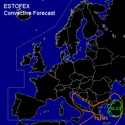

CONVECTIVE FORECAST
VALID Sun 18 Dec 06:00 - Mon 19 Dec 06:00 2005 (UTC)
ISSUED: 17 Dec 20:14 (UTC)
FORECASTER: DAHL
There is a slight risk of severe thunderstorms forecast across W Turkey.
SYNOPSIS
Strong mid/upper vort max at the periphery of large-scale central European longwave trough currently digging into the north-central Mediterranean ... will reach W Turkey/W Black Sea by Monday morning. Strong low-level thermal boundary is curving from the British Isles southwards across the W Mediterranean ... S Italy ... the S Balkans and then northwards across the N Black Sea into W Russia. Rather intense frontal wave has developed ahead of Mediterranean vort max over central Italy along that boundary ... and is expected to move downstream ... reaching the E Ukraine by the end of the forecast period.
DISCUSSION
...W Turkey...
Weak instability is expected to develop ahead of the cold front over the Aegean and W Turkey. Though degree and extent of instability remains uncertain at this time ... quite strong shear profiles will be in place ... and any isolated TSTM that forms will have potential for acquiring rotation ... posing a threat for severe hail/wind gusts ... and tornadoes. Significantly backed ... and strong SFC winds are simulated to boost 0-3 km SRH values ... GFS 12Z assumes peak SRH values in excess of 400 J/kg ... and 0-1 km SRH in excess of 300 J/kg. Though allover thermodynamic setup is likely to be very weak ... and TSTMS may be rather isolated ... strong shear profiles make a SLGT necessary ATTM.
Shallow TSTMS should develop in the postfrontal environment over the Adriatic Sea. Severe threat seems to be quite limited with this activity however.
#