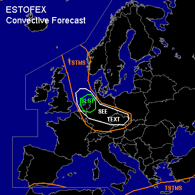
CONVECTIVE FORECAST
VALID Fri 16 Dec 06:00 - Sat 17 Dec 06:00 2005 (UTC)
ISSUED: 15 Dec 21:14 (UTC)
FORECASTER: TUSCHY
There is a slight risk of severe thunderstorms forecast across the Netherlands and NW Germany
SYNOPSIS
Impressive 24 hours will be imminent for parts of N- and CNTRL Europe!
Downstream of a strong and well defined anticyclone west of Europe, an outbreak of arctic air will unfold during the forecast period and will affect most parts of northern and central Europe....Embedded in an active baroclinic zone [Island - Scotland - Germany , a developing low pressure system will undergo intense strengthening over NE Germany / W - Poland, while racing SEward...Furthermore, lee cyclogenesis is forecasted to develop during the latter part of the forecast period over the Ligurian Sea.
A system over the extreme SE Mediterranean [ which showed some signs of subtropical cyclone development yesterday ] will exit the forecast region, but broad area of low geopotential heights should help for some storms to develop....A pocket of cool mid-level airmass over the extreme SW Mediterranean will also help for some isolated storms to develop... Otherwise, most parts of eastern Europe will feel the affects of a stable and cool airmass, which should suppress TSTM development.
DISCUSSION
...the Netherlands and NW Germany...
Intense depression will rapidly race SE ward over NE Germany [morning hours], Poland [ during the noon and afternoon hours ], reaching Belarus during the late night hours... Left exit region of outstanding 165kt H3 jet and
very active baroclinic zone support this development....
First area to watch for TSTM development will be the cold front, attending the intense LL depression...Obviously, main concern will be instability release...Prefrontal advection of marginal higher dewpoints (Theta-E tongue) is forecasted by model pool...this, combined with strong height falls, impressive forcing along the cold front, strong UL divergence and locally enhanced lift ( topographically induced ) should yield the possibility for isolated SFLOC reports... especially in the SEE TEXT area.
Kinematic parameters will be impressive with up to 20m/s LL-shear and low LCLs with a risk for an isolated tornado... Main risk will be severe to damaging wind gusts with DLS in the order of 40m/s+ ... H85 wind field also very strong [ up to 35m/s ]and steepening LL lapse rates should be conducive for strong downward-impulses... Current thinking is that threat of convective induced gusts will be marginal ( reason for not upgrading ATM ), but each weakly electrified storm will pose a significant wind gust threat!
Next area of interest will be the SLGT area during the night hours... Extremely cold H5 airmass [ ~ -43°C ]will
arrive during the midnight hours in the risk area... Latest buoy reports show SSTs in the range of 10 - 11 °C... This combination will help for SBCAPE values in the range of 200 - 400 J/kg, which should be advected well inland ( although rapidly diminishing )...During the past few runs, GFS showed a weak disturbance moving onshore during the 00-03Z time frame, which should help for some forcing...Again, impressive UVV values present under LE region of UL/ mid- level jet in a zero-capped environment... Current thinking is that TSTMS will increase in coverage over the S-North Sea, moving onshore in the SLGT area... LL shear enhanced with up to 15m/s and SRH-1 values in the order of 300m**2/s**2... Very steep LL lapse rates present in an environment with 30m/s H85 flow, so main risk will be severe wind gusts/white-out conditions... Low LCL also favors an enhanced tornado threat in the risk area!... Despite the bad timing, conditions look favorable for a few TSTMs to develop in the risk area during the latter part of the forecast period.
#