CONVECTIVE FORECAST
VALID Sun 11 Dec 06:00 - Mon 12 Dec 06:00 2005 (UTC)
ISSUED: 10 Dec 15:41 (UTC)
FORECASTER: TUSCHY
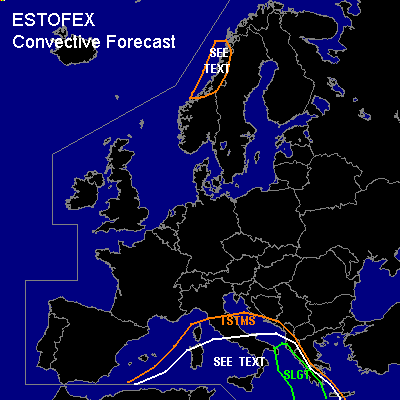
There is a slight risk of severe thunderstorms forecast across eastern parts of the Ionian Sea
SYNOPSIS
Polar front jet continues to be very disturbed with a couple of streaks, moving over Europe and a well developed subtropical jet which merges with the far southward diverted polarfront jet over parts of the south - eastern Mediterranean...Main feature for convective activity will be a developing cut-off system over the central Mediterranean, which should be nearly stationary for the next 24 hours....Further northward, intense cyclogenesis forecasted by all models, which will affect parts of Norway during the forecast period...Otherwise, most parts of central and eastern Europe will see influx of a cool and stable airmass, which should suppress convection development
DISCUSSION
...eastern parts of the Ionian Sea...
Broad UL cut off system will be placed over the central Mediterranean...Conditions appear favorable for widespread
TSTM development ( especially in a triangle Sardegna - Sicilia - central Italy , where cool mid-level airmass will be present over SST of ~ 16 °C )in an environment with low kinematic values... Don't want to exclude the possibility for one or two waterspouts along the coastal areas, but general threat looks too marginal for warranting higher probabilities.
Main concern for organized TSTMS will be found in the SLGT area... Warm front is forecasted to shift northward during the forecast period, reaching the coastal areas of Albania during the early afternoon hours... This warm front will be coupled with a low-level depression, which should develop south of Italy in a left exit region of a 110kt - UL jet... Advection of warm and moist airmass downstream of this system over the risk area will help to create an unstable airmass with up to 500 J/kg SBCAPE southwest of Albania ---- only increasing further to the south...As a consequence of the developing LL depression, backing wind field is forecasted to develop in the NE Ionian Sea, which would significantly enhance shear parameters (+ arriving 75kt mid-level jet from the SW )and there will be an enhanced severe wind gust/ tornado threat mainly offshore, where surface based storms can be expected.... Further southward along the western coast of Greece, strengthening pool of instability, long-lasting forcing, weakly capped airmass and pretty high PWAT values should allow a cluster of storms to develop...Enhanced LL shear ( up to 15m/s ) should admit some storms to organize with an isolated tornado threat...Main risk will be a few severe wind gusts along the coastal areas and also increasing flash flood potential in the coastal areas of the SLGT risk.
...parts of the western Norwegian coast...
Intense cyclogenesis with accompanying cold front will come onshore during the late afternoon hours... Very limited instability forecasted, but strength of forcing of cold front and enhanced upslope flow on the luff of the Norwegian mountains should allow a few, weakly electrified storms to develop with an isolated severe wind gust risk.
#