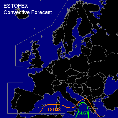

CONVECTIVE FORECAST
VALID Sat 10 Dec 06:00 - Sun 11 Dec 06:00 2005 (UTC)
ISSUED: 09 Dec 21:39 (UTC)
FORECASTER: DAHL
There is a slight risk of severe thunderstorms forecast across the Ionian Sea.
SYNOPSIS
Main feature this period will be quasi-stationary upper low over the central Mediterranean ... which exhibits several vort maxima at its periphery. SFC low now over the W Mediterranean is progged to continue its weakening trend ... while weak cyclogenesis is progged over the Ionian Sea late in the period along baroclinic zone stretching from the SE Black Sea into the central Mediterranean. Otherwise ... large SFC high is sprawling across the rest of Europe ... maintaining quite unfavorable environment for deep convection.
DISCUSSION
...Ionian Sea...
Currently available sounding data do not sample plume of warm/moist air spreading across the Ionian Sea ... but satellite and lightning data suggest that model CAPEs are too modest in extent ... any maybe also in intensity. MLCAPEs of roughly 500 J/kg may be realized over the Ionian Sea on Saturday. Current thinking is that convective activity will strengthen across the Ionian Sea during Friday night and move across W Greece ... with additional development expected on Saturday afternoon/evening in response to developing frontal wave ... affecting mainly the central portions of the Ionian Sea ... maybe reaching S Italy in the night hours.
Deep shear of about 20 m/s should be favorable for severe evolution ... and organized multicellular storms may form over the Ionian Sea ... moving towards S Italy and the S Adriatic Sea late in the period. Expect a few severe wind gusts and possibly some marginally severe hail ... especially with imbedded mesocyclones. Also ... a brief tornado or two may occur. TSTMS over W Greece should be driven by low-level warm advection and may tend to be elevated ... with limited severe threat.
#