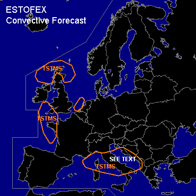
CONVECTIVE FORECAST
VALID Tue 06 Dec 06:00 - Wed 07 Dec 06:00 2005 (UTC)
ISSUED: 06 Dec 02:14 (UTC)
FORECASTER: VAN DER VELDE
SYNOPSIS
A large upper low has settled over Europe, several shortwave troughs circle around at its periphery. A higher theta-e wave over the Adriatic/western Balkan under the strongest PVA of the 500 hPa trough nose deepens a low slightly at the beginning of the forecast period, while the low moves NNE-ward to Poland.
DISCUSSION
...SEE TEXT Mediterranean and Adriatic Sea...
Previous day soundings have indicated strong low-level lapse rates and buoyancy, e.g. Pratica di Mare. At midlevels strong winds will be present. These conditions may lead to strong convective gusts, marginally large hail and waterspouts, also from mesocyclonic updrafts that may briefly develop in areas with strong sr-helicity. GFS and NMM models indicate the strongest LL shear and SREH are induced by friction over land, however the heat source of CAPE is the warm sea water, so inland the risk of tornadoes decreases rapidly.
...TSTM areas...
not much activity is expected except for a few isolated strikes.
#