CONVECTIVE FORECAST
VALID Mon 05 Dec 06:00 - Tue 06 Dec 06:00 2005 (UTC)
ISSUED: 04 Dec 22:53 (UTC)
FORECASTER: GROENEMEIJER
SYNOPSIS
The mid-level flow and upper-level flow is dominated by a low pressure area over the North Sea filled with cold air at mid and upper levels. A cyclonically-curved jet flows to its west, south and southeast.
DISCUSSION
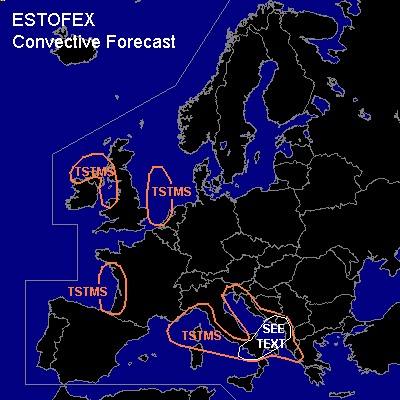
...Italy, Adriatic, west-central Balkans...
As a shortwave trough approaches the area from France, increased destabilisation is expected and a couple of 100's J/kg of MLCAPE should become available for deep convection. In the area marked 'SEE TEXT' the ingredients for strong and perhaps a few severe convective storms may briefly come together in the 18-06 time frame as strong shear continues over the area while lift is expected ahead of the shortwave trough.
Low CAPE should limit the threat of large hail though and wind profiles are not exhibiting a lot of potential for high values of storm-relative helicity to form. Nevertheless a few mesocyclones could occur given the strong low-level shear, presenting a small threat of tornadoes. Additionally some stronger gusts seem possible in places given that winds at 850 hPa will likely exceed 20 m/s.
The overall threat, however, is too low to warrant a risk category.
#