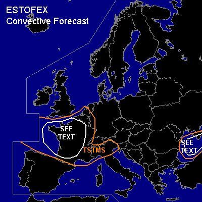

CONVECTIVE FORECAST
VALID Sun 04 Dec 06:00 - Mon 05 Dec 06:00 2005 (UTC)
ISSUED: 03 Dec 23:00 (UTC)
FORECASTER: DAHL
SYNOPSIS
Vort max over the central Mediterranean as of Saturday evening ... is progged to continue its eastward track across the S Balkan States and the Black Sea into the central Ukraine until Monday morning. Upstream ... vigorous vort max will spread across the Gulf of Biscay and France into Germany on Sunday ... with its southern portions moving into the N Mediterranean ... promoting weak cyclogenesis over the N Adriatic Sea late Sunday night. Otherwise ... large vertically stacked low pressure system remains anchored over the central British Isles.
DISCUSSION
...France...
Focus for convective development will be strong vort max which should reach France in the early afternoon hours. Though models do not indicate strong SFC convergence to be associated with this feature ... potential exists that field of enhanced cumuli S of Ireland on Saturday evening will continue to organize. This is supported by 850 hPa theta-e and T fields indicating development of weak baroclinic zone ahead of the vort max ... which may support mesoscale circulation sufficiently strong to sustain comma-cloud type system. Main negative will be the cold temperatures/weak diabatic SFC heating over France ... so that the system may fall apart rather quickly as it makes landfall. Shear profiles will be more than adequate for organized convection ... main threat being strong/severe straight-line winds though an isolated marginally-severe hail event and a tornado or two cannot be ruled out given low LCL's ... anticipated weak/no capping and strong low-level shear. Uncertainty on the mesoscale evolution of EC field currently associated with the vort max ... and limited confidence that the system will survive its landfall preclude a categorical risk ATTM. Like on Saturday ... isolated lightning may occur with shallow convection over the North Sea ... but activity should remain too isolated for a TSTM outlook.
...Black Sea...
Isolated lightning may continue ahead of the vort max crossing the Balkans during the first half of the period ... but activity should rejuvenate in the late afternoon/early evening hours over the Black Sea in the vicinity of developing small SFC low. Low-level shear seems to be limited ... but 20+ m/s deep shear may support an isolated strong/severe wind gust or two and possibly some hail ... which may briefly attain severe levels. However ... minimal instability and modest forcing for ascent suggest that severe threat will be rather low.
#