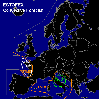

CONVECTIVE FORECAST
VALID Sat 03 Dec 10:00 - Sun 04 Dec 06:00 2005 (UTC)
ISSUED: 03 Dec 09:29 (UTC)
FORECASTER: DAHL
There is a slight risk of severe thunderstorms forecast across central Italy and the central Adriatic Sea.
SYNOPSIS
Vort max ejecting from intense upper long-wave trough centered over the British Isles will move across the W and central Mediterranean into the Aegean Sea by Sunday morning. Large-scale quasi-stationary and intense SFC low-pressure system is covering the WRN portions of Europe ... with weak southward extension developing over the N Italy/Adriatic Sea/NW Balkans downstream from Mediterranean vort max on Saturday.
DISCUSSION
...central Mediterranean...
Cold front associated with the Mediterranean vort max now extending across the NW Mediterranean Sea will push east and reach the Ionian Sea/S-Balkan region towards the end of the period. Plume of unstable air ahead of the front is poorly sampled by radiosonde network ... but indications are that MLCAPE is only on the order of a few hundred J/kg ... though lapse rates seem to be rather steep in the lowest levels with weak capping. TSTM activity should increase some along and ahead of the front as DCVA-related forcing for UVVs spreads across the warm-sector air mass. Though shear may be somewhat reduced over the water owing to reduced friction ... strong LL and DL shear are expected over land ... so that a few organized severe TSTMS should occur. Main threat seems to be severe wind gusts ... though a brief tornado and some hail may occur as well especially in association with mesocyclones.
...Gulf of Biscay ... W France...
Cellular convection should persist in deep polar air over the E Atlantic ... and the is spreading across France into the W Mediterranean ... where it should diminish during the next few hours. Organization of TSTMS will likely be limited given weak/no focused low-level mesoscale forcing for ascent ... but a short-lived mesocyclone or two could form given rather strong shear ... especially over the W coast of France. These may briefly account for marginally severe hail ... damaging wind gusts and possibly also a tornado or two. However ... bulk of activity should stay off-shore ove the E Atlantic. Isolated lightning may also occur farther N over the North Sea ... but TSTMS should be too isolated to necessitate a TSTM area.
#