CONVECTIVE FORECAST
VALID Fri 02 Dec 06:00 - Sat 03 Dec 06:00 2005 (UTC)
ISSUED: 01 Dec 20:52 (UTC)
FORECASTER: TUSCHY
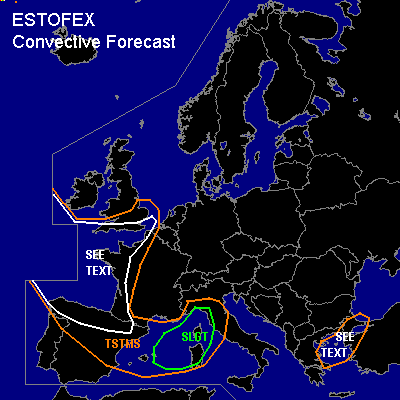
There is a slight risk of severe thunderstorms forecast across parts of the central Mediterranean area
SYNOPSIS
Broad area of low geopotential heights covers most parts of Europe...Main feature of interest will be an intense trough over western and northwestern Europe... A weakening, but yet pretty strong UL jet on the upstream side of this system [ about 110kt at 300hPa while circling around the tip of this trough ] will help for a more negatively tilted trough during the next 24 hours... Widespread decrease of pressure forecasted in the left exit region of UL and mid-level jet over parts of north-central Mediterranean area with a weak LL depression forecasted to develop...Extreme SE Europe will again feel the effect of unseasonable WAA downstream of this broad area of lower geopotential heights, although influence of ridging will continue to weaken, because of an eastward shift of ridge axis.
DISCUSSION
...parts of the central Mediterranean area...
Most models agree fairly well of the track of a weak LL depression, which is forecasted to move over SE France towards the Ligurian Sea during the latter part of the forecast period...but they disagree about the status of the depression ( open wave or closed low pressure area ). Current thinking is that an open wave will reach the risk area during the late afternoon hours...strengthening WAA, downstream of this system will help to force a warm front northward towards the coastal areas of extreme SE France/ NW Italy...Models forecast development of a slightly unstable airmass in the warm sector over the risk area [ GFS showes patches of 500 J/kg SBCAPE ...LL shear enhanced along the coastal areas (up to 15m/s )] which favors an enhanced tornado/ severe wind gust risk.
Next region for convection development will be the ESE-ward moving cold front, entering the risk area during the midnight hours with an attendant severe wind gust risk [ 500hPa jet up to 70kt and DLS in the order of about 25m/s ].
...the Celtic Sea,Bay of Biscay, northern Spain, western and northern France, the English Channel and southern United Kingdom...
Latest IR loops show a well developed low level depression southwest of Ireland [ latest pressure reading : 971hPa at 20 UTC, 01.12.05 ]and broad area of enhanced convection W/NW of the center...Until now, only weakly electrified storms are en-route, but expect an increase in SFLOC reports, when pool of pretty cold mid-level airmass [500hPa ~ -35°C] will continue its southward motion... Water temperatures about 12-14°C will be conducive for steepening lapse rates and models forecast widespread 300 - 500 J/kg SBCAPE...Enhanced LL shear along the coastal areas (10 to 12m/s ) will favor the chance for some storms to organize with an enhanced waterspout/tornado threat... Although DLS is pretty low, a relatively deep layer of instability and steepening low-level lapse rates would be enough for a downward momentum transfer of a strong jet in H85( 65kt in 850hPa over NW France ) with a threat for severe wind gusts with each convective storm---especially along the NW coast of France....Instability is forecasted to be advected inland over western/northwestern France, so extended TSTMS area well inland in this region... main threat will be a severe wind gust and marginal hail risk.
...the Aegean Sea and northwestern Turkey...
Northeastward shifting UL-trough axis with attendant cooler mid-level air will help for isolated to scattered TSTM development during the night hours....The critical point will be the instability...only low-end values forecasted over the area...Current thinking is that at least 100 - 200 J/kg instability can develop under the NE-ward shifting trough axis, which would be enough for a few storms to generate...Each developing storm would be in an environment with very strong DLS, so severe wind gusts can be expected... Especially the coastal areas of the NE Aegean Sea should also see slightly enhanced LL shear ( particulary if model trend verifies, developing a weak LL depression in this area )....don't want to exclude the possibility for one or two tornadoes in this region...Uncertainness of final magnitude of instability precludes me for issuing a risk category.
#