CONVECTIVE FORECAST
VALID Mon 28 Nov 06:00 - Tue 29 Nov 06:00 2005 (UTC)
ISSUED: 27 Nov 21:57 (UTC)
FORECASTER: GROENEMEIJER
SYNOPSIS
Monday at 06Z... the mid/upper-level flow across Europe is dominated by a broad and highly amplified trough along an axis from the Norwegian Sea to the western Alps. A jet streak extending from Tunisia to eastern Romania moves downstream into the central Ukraine. Along a cold front extending from northern Belarus southward over the eastern Balkans and the Aegean Sea, a baroclinic wave is expected to develop over Romania. The deepening cyclone at the wave's tip is forecast to move quickly northward into Moldova, the Ukraine and, later, western Russia. Across western Europe, a shortwave trough extending WSW-ward from the Channel region slowly moves southward.
DISCUSSION
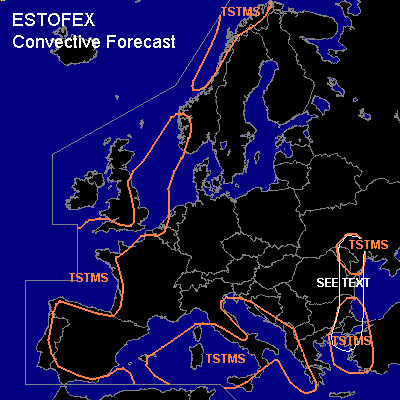
...Eastern Balkans, western Turkey, eastern Greece...
Ahead of the aformentioned cold front a plume of high theta-e air is advected northward during the morning hours by a 25+ m/s low-level jet. A few 100s of J/kg surface-based CAPE will likely develop in some places ahead of the front. GFS 2712 suggests this is most likely across the eastern Aegean Sea and across northeastern Romania and Moldova during the morning and early afternoon. A few thunderstorms will likely form. Given the anticipated strong deep-layer shear, a couple of storms may develop rotating updrafts or become otherwise well-organised so that a marginal threat of strong winds will exist. Additionally, low-level shear across northeastern Romania and Moldova should be strong with bulk shear well in excess of 10 m/s expected there, which in combination with a strong veering of the wind in the lowest few kilometres should enhance the chance of a tornado to form there. However, the overall risk will be limited across the SEE TEXT area by weak CAPE values.
#