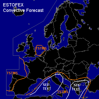

CONVECTIVE FORECAST
VALID Sat 26 Nov 12:00 - Sun 27 Nov 06:00 2005 (UTC)
ISSUED: 26 Nov 11:24 (UTC)
FORECASTER: DAHL
SYNOPSIS
Deep large-scale quasi-stationary upper trough is extending from SW into NE Europe ... resulting in broad and vigorous SWLY upper flow from the SW Mediterranean into NE Europe. Deep polar air has spread across SW ... central and NRN Europe ... with modified subtropical air existing over the W Mediterranean regions. Frontal wave is developing over the Gulf of Genoa ahead of one of various vort maxima imbedded in the mean SWLY flow ... and should move into the NRN Balkan States during the period.
DISCUSSION
...western Mediterranean...
Instability is progged ... and oberved ... to be rather weak ahead of the cold front spreading across the W Mediterranean today. Expect some increase in TSTM coverage and intensity as rather strong DCVA regime overspreads the front later today/tonight. Shear profiles should also increase some ... with 500 hPa flow of up to 35 m/s ... and 850 hPa flow on the order of 20 m/s ... providing favorable kinematic profiles for isolated severe TSTMS. Dominant convective mode should be short line segments ... in which short-lived bows and mesocyclones may be imbedded ... primarily posing threat for strong/severe outflow winds ... and possibly a few tornadoes given low LCLs and strong LL shear ... though details of low-level thermodynamic setup in the immediate environment of the front remain uncertain. Isolated large hail may also occur but should be confined to mesocyclones. Allover threat seems to be too low for a SLGT.
...Ionian Sea ... Greece ... Aegean Sea...
Farther east ... steep lapse rates associated with elevated mixed Saharan air mass should enhance capping ... but also increase CAPE somewhat. Thinking is that scattered TSTMS will form later this afternoon over the Ionian Sea ... Greece and and the Aegean Sea. Shear profiles seem to be slightly weaker than farther west ... but should still be sufficient for maintaining some severe threat across that region. Rather strong LL shear suggests that a few tornadoes may occur ... but especially over Greece and the Aegean ... storms may tend to be elevated. Main threat should be strong wind gusts and isolated marginally severe hail ... but likely too isolated for a SLGT.
...Gulf of Biscay ... NW Spain ... Portugal...
Cellular convection should persist across and SW of the Gulf of Biscay .... advecting into the Spanish/Portugese coastal regions. Organized severe threat should be limited given rather unimpressive kinematic/thermodynamic setup ... but a few strong wind gusts and possibly some small hail could occur. Organzied severe threat looks to be rather slim, however.
#